


Laura Heckmann
Situational awareness once depended on outdated maps, phone tag and spotty internet connections. Today, edge computing technology is providing situational awareness to the warfighter in minutes.
Delayed information in a contested environment literally weaponizes time, said Ki Lee, chief technology officer at Booz Allen Hamilton’s global defense sector.
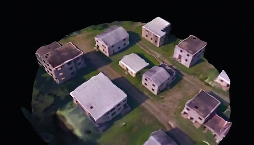
Booz Allen invested in small business Reveal Technology to fight time with decentralized data. Reveal created a platform called Farsight — a software application that receives images from drones or surveillance platforms and rapidly creates three-dimensional, situational awareness products for mission planning.
While Defense Department operations have become “much more decentralized” over the past decade, “from a data perspective, the prevalent pattern is to centralize data — bring that data from the sensor to the ground station, copied over numerous times to every single operation center,” Lee said.
The time lag created in the data’s slog through a centralized model is “huge,” Lee said. “Our technology, and what we wanted to do, was actually extend from the centralized pattern to a decentralized pattern through a data mesh.” Booz Allen modeled the internet, he said.
Booz Allen’s internet model and data mesh concept allow data discovery and access “where it exists without having to move it,” he said. “You’re accessing it where it persists, and it’s resilient. It’s available wherever you’re at.”
Reveal’s CEO Garrett Smith defined the “edge” as the point at which tactical decisions are being made and executed. And that’s exactly where he’s bringing the data.
Farsight’s AI-powered capabilities include real-time 2D and 3D mapping, line-of-sight analysis and route planning. A tour of the website reveals red and green-blotched layouts of thermal imaging, vertical measurement tools and detailed 3D models equipped with drag-and-rotate features that allow clicking through city streets and swirling around aerial views.
The software allows for rapid creation of geospatial intelligence by operators at the point of decision, Smith said. Untethered from distant headquarters, the software is organically controlled and owned “right there on the edge.” Historically, entities operating in tactical environments were reliant on higher headquarters or remote processing and exploitation intelligence cells for situational awareness, Smith said. “They were kind of left to their own devices.”
Unencumbered by network requirements and higher headquarters, “they’re in control of their own destiny,” he said. “They know their problem better than some remote location. They need to be driving the bus on answering their own questions whenever possible.”
The software lives on mobile handsets being carried by tactical operators, such as a Samsung Galaxy smartphone. The app can ingest streaming videos or images from a drone platform and rapidly create scenes in 3D for situational awareness and sharing, Smith said.
In Ukraine, soldiers used the software to navigate the urban environment of Zhytomyr last summer and gain awareness of Russian positions around the city, he said.
Real-time video information collected from drones and streamed down to mobile devices was converted within one to three minutes into a full 3D scene, which was used to plan a safe route across the city, Smith said.
In a hypothetical vignette, the software could be used for advanced reconnaissance in the Indo-Pacific. Operators on a poorly mapped island could rapidly assess terrain viability for helicopter and airplane landings on the island or detect a Chinese anti-air battery and call in an air or naval strike from “somewhere over the horizon.”
Having access to real-time situational awareness is significant in environments such as Ukraine and the Indo-Pacific because they are often GPS or communications-denied environments, Smith said. In the Ukraine scenario, nearly all communications were blanket jammed within 15 to 20 kilometers of the threat, he added.
“They need to execute on organically generated intelligence,” he said.
The benefits of increased situational awareness go beyond the operator, Lee said. The decentralized internet model also opens up new possibilities for data sharing. He described creating “data containers” akin to HTML pages and registering products in a data domain naming system.
“If you register that data product into our data DNS, then it becomes globally discoverable and accessible,” he said. He predicted that three to five years down the road, tech will allow space-based communications and data being collected at the edge to be shared “not only across that tactical edge, but back to a forward operating base, and then all the way back into an operation center.”
Better data sharing and “full situation awareness” lends itself to the military’s broader goals of joint all-domain capabilities, Lee said.
“Full situational awareness across the entire joint all-domain area … it’s all the ends. This is kind of the end-to-end, multi-echelon ecosystem that we’re trying to connect,” he said.
Further contributing to the “jointness” concept, Reveal is hardware and platform agnostic, meaning the software can be deployed on to and make use of “any system that our customers or users have or want to adopt,” Smith said.
This idea is in “stark contrast” to the way the defense industrial base has operated over the past several decades, where “things were very highly proprietary, vertically integrated, where you have aircraft that can’t talk to other aircraft,” he added.
Company personnel are evangelists for edge technology, Smith said.
“We’re just trying to help adapt the technology to the operations and updated tactics, techniques and procedures,” Lee added. “So, I think that’s why this decentralized model … is evolving, and we believe it’s going to be critical as we move forward.” ND
No comments:
Post a Comment