


LT GEN H S PANAG
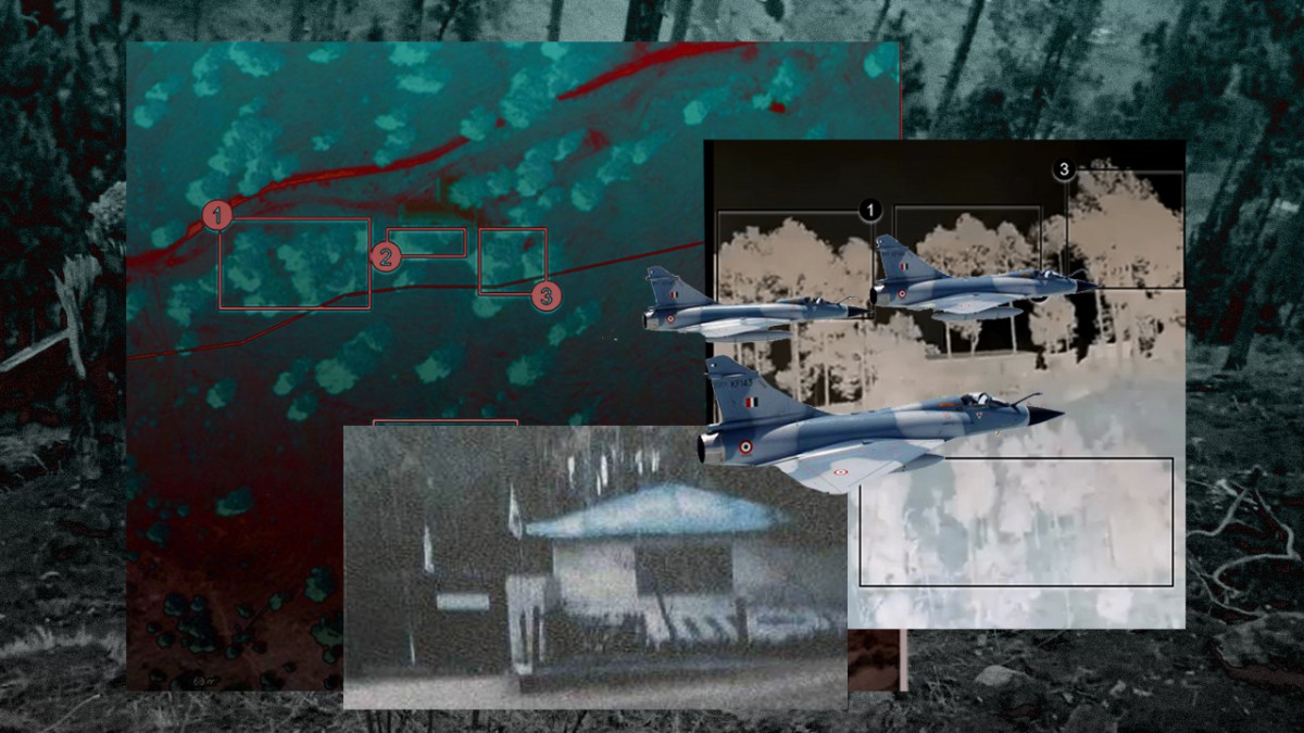
Governments and the military disseminate information to highlight successes and cover-up failures and, at times, even indulge in deception and disinformation. Social media delights in shattering the credibility of this information using open-source intelligence (OSINT). The adversary also uses OSINT to discredit governments. In India, OSINT was in the news during the Balakot strikes and the air skirmishes that followed on 26 and 27 February.
OSINT and multiple versions
OSINT has been the primary source of basic intelligence with respect to a target country and its armed forces. Its collection and collation are a long-term process. Based on this data bank, intelligence resources are deployed to collect specific information to decide when, where and how the threat will manifest.
During the Balakot strikes, OSINT sources used commercial websites like www.flightradar24.com to put out sensitive information regarding the movement of Indian military aircraft. Subsequently, well-known OSINT handles like ElintNews, Intellipus, IntelCrab were temporarily taken off Twitter (following ‘requests from India’) for spreading disinformation and “violating Indian laws”.
Recently, defence analyst Abhijit Iyer-Mitra used a series of images provided by OSINT handles to argue in ThePrint that the Chinese have constructed a road in Bishing sector in Arunachal Pradesh. The Army clarified that indeed a road was ‘inadvertently’ constructed by the Chinese in 2017, and the issue was resolved through border management mechanism. Trees were planted on the road and a wall was constructed to clearly mark the LAC, the Army said. Mitra countered this version by offering latest satellite imagery to prove his point. The jury is still out on this issue.
What is OSINT?
OSINT is information/data/intelligence collected from publicly available or open sources as opposed to covert or clandestine sources. All intelligence agencies across the world collect, collate and analyse open-source intelligence or OSINT.
The sources of OSINT are internet, media, academic/professional publications, published government data/statistics and commercially available analysis by professional organisations.
In the last three decades, revolutionary advances in easy-to-use electronic devices coupled with the vast reservoir of information available on the internet has made OSINT accessible to everyone. OSINT experts also make such data available commercially.
Threat posed by OSINT
All governments have taken various measures to protect sensitive data, with some drafting tough laws. Armed forces have elaborate security procedures to deny information through strict and enforceable rules and regulations. All these conventional security precautions were fairly effective till a few years ago. While basic intelligence could be collected, but specific information was hard to access. However, with advances in technology, even specific intelligence can now be collected. Let me prove the point by a few examples.
Northern Command, for instance, has a budget of Rs 300 crore for emergent purchases under the Army Commander’s special financial powers. As per the government’s financial procedures, the tenders are floated on the internet. A mere analysis of the tender notices can provide basic information about specialist weapons and equipment being bought and the shortages prevailing in the Northern Command.
In mountains, given the nature of the terrain and the space limitation, defences are located on hill tops/ridges and artillery gun positions and logistic bases in the narrow valleys. Any military expert can use Google Maps and Google Earth to identify these locations with fair accuracy. After this, all that remains is determining the quality and quantity of fire power and units/formations needed to destroy or capture them.
The countermeasures, in such a scenario, are camouflage/concealment, hardening of defences and tunnelling. Forcing Google to blur the military installations or large swathes of sensitive terrain is a double-edged sword, and in any case the damage has already been done.
Similarly, aviation and sea-faring safety demands that information of all aircraft and ships is in public domain. Military aircraft/ships do switch to encrypted military transponders during operations. But when moving through civil air/sea space, the ‘civil mode’ is switched on for safety reasons – which allows tracking of the aircraft/ship to discern intentions. The countermeasures are deception and closing of air/sea space to civilian aircraft/ships. Again, closing of air/sea space is not a pragmatic option during undeclared conflict situations.
Threat to credibility
Public perception drives the actions of democratic governments and their military. And, this depends on the credibility of the information, which is increasingly being challenged by OSINT handles.
The best way to counter this threat is by providing not just credible but irrefutable proof of actions. The other alternative is to prepare an elaborate deception plan to sustain the desired narrative.
During the Balakot strikes and the dogfight the day after, incisive investigation, deception and disinformation based on OSINT left a cloud of ambiguity over claims of both India and Pakistan.
The IAF failed to formally exploit the most credible OSINT about shooting down of the F-16 in the form of videos shot by civilians in Pakistan-occupied Kashmir as well as Indian citizens from our side of the Line of Control. It was left to the OSINT enthusiasts to prove the point.
No comments:
Post a Comment