By SYDNEY J. FREEDBERG JR.
WASHINGTON: In the 100-degree heat of the Yuma desert, Army troops are getting glimpses of how artificial intelligence can help their future fight. Aerial reconnaissance data automatically fills handheld digital maps with threats and targets, while smartphone apps allow them to take temporary control of passing drones to look through their sensors and fire missiles – that is, when the networks work and the tires don’t blow.
“We’ve had Grey Eagle tires exploding on the ramp because it’s so darn hot,” Brig. Gen. Walter Rugen told me. “Some guys [are] working 20 hours a day” to get different Army systems to exchange data they were never designed to share.
But the whole point of the Army’s Project Convergence exercises at Yuma Proving Ground this fall is to take the service’s big ideas for future warfare and test them in the real world. The Army wants to figure out what works and what needs fixing – and figure that out as early on as possible, when it’s much cheaper to make changes. That’s what the service failed to do in its last attempt to link drones and ground troops this ambitiously, the Future Combat Systems program, cancelled in 2009.
11 years later, technology may finally be catching up to the vision. In one recent test, Army Futures Command chief Gen. John Murray said last week, AI data-processing algorithms were able to cut the time from detecting a target to firing at it with artillery – a “kill chain” that normally takes tens of minutes to complete – down to 20 seconds.
Brig. Gen. Rugen is working the air support piece of that complex equation. As head of the modernization team for Future Vertical Lift, he oversees development not only of new high-speed Army aircraft to replace existing helicopters and drones, but of the electronics and technical architectures linking them together. In this fall’s experiment, the Army is using off-the-shelf surrogates to try out technologies and tactics for future fleet it plans to build.
Army MQ-1C Grey Eagle
At Yuma, Rugen’s team is flying three heavily modified RQ-1C Grey Eagles (the upgraded Army version of the Predator), a long-range drone that can fly missions of up to 40 hours, depending on the variant. These drones were already customized with new electronics for previous experiments and have flown over 1,200 hours in the last two years, Rugen told me. In Project Convergence, they’re are carrying a variety of payloads, including electronic warfare systems to detect and disrupt enemy transmissions at long range.
The big innovation here, Rugen said, is a prototype plug-and-play interface – an early version of the future Modular Open Systems Architecture (MOSA) – that makes it much easier and quicker to get a new pod to work on the drone for the first time, without laborious technical integration or time-consuming safety recertifications.
“We don’t have to necessarily go back to the OEM [Original Equipment Manufacturer] and pay to have it integrated,” he told me. “The pace has been amazing. It’s cut at least … 12 to 18 months off of the process.”
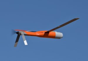
ALTIUS mini-drone in flight over Yuma Proving Ground.
The team is also using ALTIUS mini-drones, which can be launched like missiles from Army helicopters – in this experiment, a pair of UH-60 Black Hawks – and then be recovered for reuse by teams on the ground. This exercise is the first time the Army’s tried out the recovery system, which uses a cable to catch the drone, Rugen said. Before, the mini-drones just belly-landed. While both their airframes and their electronics are fairly cheap, the Army would still like to reuse them when possible.
ALTIUS, which has flown over 200 hours in Army experiments so far, is a surrogate for a future system called Air-Launched Effects, which envisions manned scout helicopters launching swarms of mini-drones to blanket the battlefield. At Yuma so far, the team has had “six ALEs up at once, covering approximately 60 kilometers,” Rugen said, but they’ll soon grow the swarm to eight.
Both the short-range ALTIUS mini-drones and the larger, longer-ranged Grey Eagles are autonomous enough to re-route themselves around reported dangers, from bad weather to suspected surface-to-air missile sites. “The aircraft knows how to fly,” Rugen said. “We don’t need to fly the aircraft [by remote control]; that’s what we can automate.”
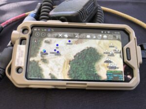
A Samsung Galaxy loaded with the military’s ATAK command-and-control software
But if soldiers on the ground want to take some degree of manual control, they can, Rugen said. Using the smartphone-based Android Tactical Assault Kit (ATAK) or its Windows equivalent, WINTAK, troops can tell a drone where to look with its sensors, have it strike a target or give it a new course.
The most important thing the drones are doing, however, is completely automatic – when it works. They’re feeding real-time reconnaissance data to the tactical wireless network. The network algorithms combine that data with information from other sources to update the digital maps troops see on ATAK and WINTAK, match threats to the best weapon to take them out, and download targeting data to fire control systems like the artillery’s AFATDS.
In the network at Yuma, “there’s an upper tier, there’s a ground tier, there’s an aerial tier, and then we’re working on that air-ground tier — and that has been the bulk of the work, because that’s hard,” Rugen told me. “That network is, at times, populating the Air-Ground COP” – the Common Operational Picture of friendly and enemy forces displayed on the digital map.

Multi-Domain Operations, or All Domain Operations, envisions a new collaboration across land, sea, air, space, and cyberspace (Army graphic)
Getting all these systems to work together is a huge team effort, Rugen emphasized. His partners include Project Maven, the Pentagon’s pioneering AI project to algorithmically find targets in surveillance data; US Special Operations Command, a pioneer in close air support for small frontline units; the Energy Department’s Sandia National Laboratories; the Johns Hopkins University Applied Physics Laboratory; and contractor TrellisWare, whose TSM waveform is the backbone of the air-ground link. For Project Convergence as a whole, he said, his Future Vertical Lift Cross Functional Team is working with the CFTs for Long-Range Precision Fires, Next Generation Combat Vehicles, the tactical network, and Assured Precision Navigation & Timing (which leads on Army use of satellite data), as well as the Army-wide task forces for Artificial Intelligence and Intelligence, Surveillance, and Reconnaissance.
Next year’s Project Convergence exercise, the Army has said, will bring in the Air Force to work on a Joint All-Domain Command & Control (JADC2) network to share targeting data between the services.
Fostering such close collaboration across bureaucratic lines is the driving purpose behind the Army’s now two-year-old overhaul of its acquisition system, which has failed repeatedly to deliver new technologies in the past. “We are now, cross-CFT, ensuring that interoperability…amongst the Army modernization efforts,” Rugen told me. “We are not in our stovepipes [anymore]. We are getting together far earlier, years earlier than anybody’s done in the past, to make sure that interoperability is there from the get-go.”
No comments:
Post a Comment