


Michael Hugos, Edward Salo, Ryan Kuhns and Ben Hazen
As evidenced in real-time by the current Russo-Ukrainian war, government leaders and military planners often miscalculate or underestimate the impact of logistics on a campaign’s success or failure. Logistics is its own dimension of warfare, and modern warfare depends on agile and adaptive supply chains to connect the defense industrial base to the warfighter. The volume and mass of supplies required to support agile, combined arms operations is significant. The Russo-Ukrainian conflict provides a compelling case study for testing, modifying, and building new strategies and doctrines in the area of contested logistics. Contested logistics has been defined as “an environment in which the armed forces engage in conflict with an adversary that presents challenges in all domains and directly targets logistics operations, facilities, and activities” both at home site or in transit to the war zone. Working with the 2022 cohort of students from the Advanced Studies of Air Mobility program at the Air Force Institute of Technology as part of a course on strategic mobility, we modeled and simulated four hypothetical Russian military scenarios and their logistics requirements. The results obtained can be used to inform current and future contested logistics strategies.
Modeling Supply Chains for Different Battle Scenarios
We created supply chain models using an off-the-shelf supply chain simulation package informed by historical and publicly available open-source data. We estimated available transportation assets (i.e., trucks, trains, airplanes) to support Russian combat units. We made rough approximations of combat unit demand using available historical data. We then identified the most likely supply routes (lines of communication) to move supplies from depots to combat units by looking at Google Maps and selecting the most likely routes based on the estimated military goals and the positioning of Russian forces.
We created our supply chain model by defining and combining four types of supply chain entities:Products—things in demand at various facilities.
Facilities—places where products are made, stored, sold, or consumed.
Vehicles—mechanisms to move products between facilities.
Routes—paths taken by vehicles to move products.
A facility can be defined as a supply depot. Another facility can be defined as the supply point for a Russian combat group, from a brigade to a combined arms army. As these facilities were defined, we placed them on a digital map. We zoomed in on the map and used the satellite view to place facilities as close as possible to their real-world locations. Then we defined vehicles such as trucks, trains, and planes, and we laid out the routes they would use to move products between facilities to meet daily demands. See the figure below for an example of how we modeled this process.
 Figure 1. Place icons on digital map to create supply chain model
The blue lines on the maps show the supply chains or lines of communication (LOCs) supporting Russian combat units involved in different battle scenarios. Each unit has an LOC or “logistics tail” that sustains it, and when that unit moves, its logistics tail must follow it—the tooth-to-tail ratio. The facilities, vehicles, and routes used to deliver the supplies needed to sustain unit operations compose these tails. And the longer the tail, the more assets are needed to get the supplies to the combat unit.
Using off-the-shelf modeling software creates supply-chain models that are easy to understand, and do not require users to have advanced math or engineering skills. These models also provide the accuracy to support strategic-level decisions without going too deeply into mathematical details or abstract network and flow diagrams. When these models are run in simulations, the map becomes the organizing framework for displaying different streams of data, such as vehicle and facility locations, supplies on hand at different facilities, and supply-chain operating costs. People can see the big picture and also analyze the details of simulation results. This is illustrated in Figures 2 and 3 below.
Our team developed and evaluated four scenarios and their logistics requirements. We then evaluated the probability of Russia being able to create and sustain the needed supply chains, and thus the likelihood of success for each scenario.
The supply chain models developed for the four scenarios each shared the following common assumptions:Russian and Ukrainian railroad gauges are the same, so Russians can use Ukrainian rail lines, but the scenario must assume the capture of cities along the path of the relevant rail lines. If this could not be assumed in the initial scenario run, students could assume it later to demonstrate the types of supply lines required to make the scenario a success.
The Russian army does not have enough trucks to meet its logistic requirements more than 160 kilometers beyond railhead supply dumps.
Ports were deemed usable if the city and immediate area are assumed secure enough to avoid persistent attacks on the port and the port has the capacity to process shipments of a useful size, as evidenced by the presence of loading cranes and container storage yards visible in satellite pictures of the port.
Invading Armies Have Vulnerable Logistics Tails
Projection of force depends on supply chains and the ability of those supply chains to operate effectively in contested logistics environments. In our investigation, we defined four scenarios:Take Kyiv and install a new regime.
Seize the east with land bridge to Crimea.
Annex the south and control Black Sea access.
Divide Ukraine and annex the east.
As we created the supply chains to support these scenarios, we saw scenarios one and four depended primarily on trucks to transport the required supplies. Scenarios 2 and 3 depended mostly on ships and railroads to move supplies. We also saw the method of transport used was directly related to the riskiness of the supply chain.
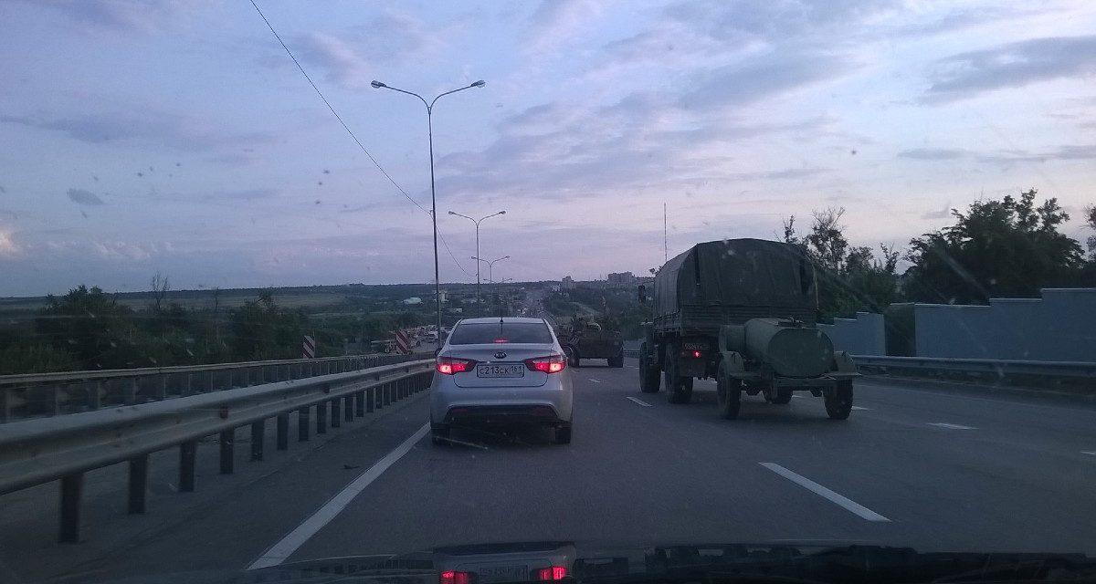
Scenarios 1 and 4 called for use of transportation routes using narrow roads, with small town passageways, narrow bridges, and wide-open plains. The screenshot below shows simulation results for a truck-based supply chain supporting scenario 4. Modern portable antitank weapons, drones, and tactics have allowed the Ukrainian military to easily stop convoys.
 Figure 2. Simulation results from Scenario 4—Divide Ukraine
Bridges and ambush locations are circled in yellow. Similar to what coalition forces witnessed in Iraq, mines, missiles, machine guns, and rocket-propelled grenades can disrupt convoys and slow down operations. Furthermore, drones flying overhead can direct Ukrainian artillery to hit stalled convoys when bridges are blown up and roads are blocked with destroyed vehicles.
Will enough supplies get through to maintain the high-intensity combat operations called for by this battle strategy? Time and again, using our best estimates, simulations show there just are not enough trucks available in Russian units to support a major attack more than 160 kilometers beyond Russian railheads or seaports.
Scenarios 2 and 3 used primarily ships and railroads to move supplies. Simulation results for scenario 3 are shown below. This strategy requires taking the Port of Odesa as a critical part of the maritime supply chain. To date, the port is still in Ukrainian hands. It appears that any amphibious or airborne assault to seize Odesa would be “suicide.”
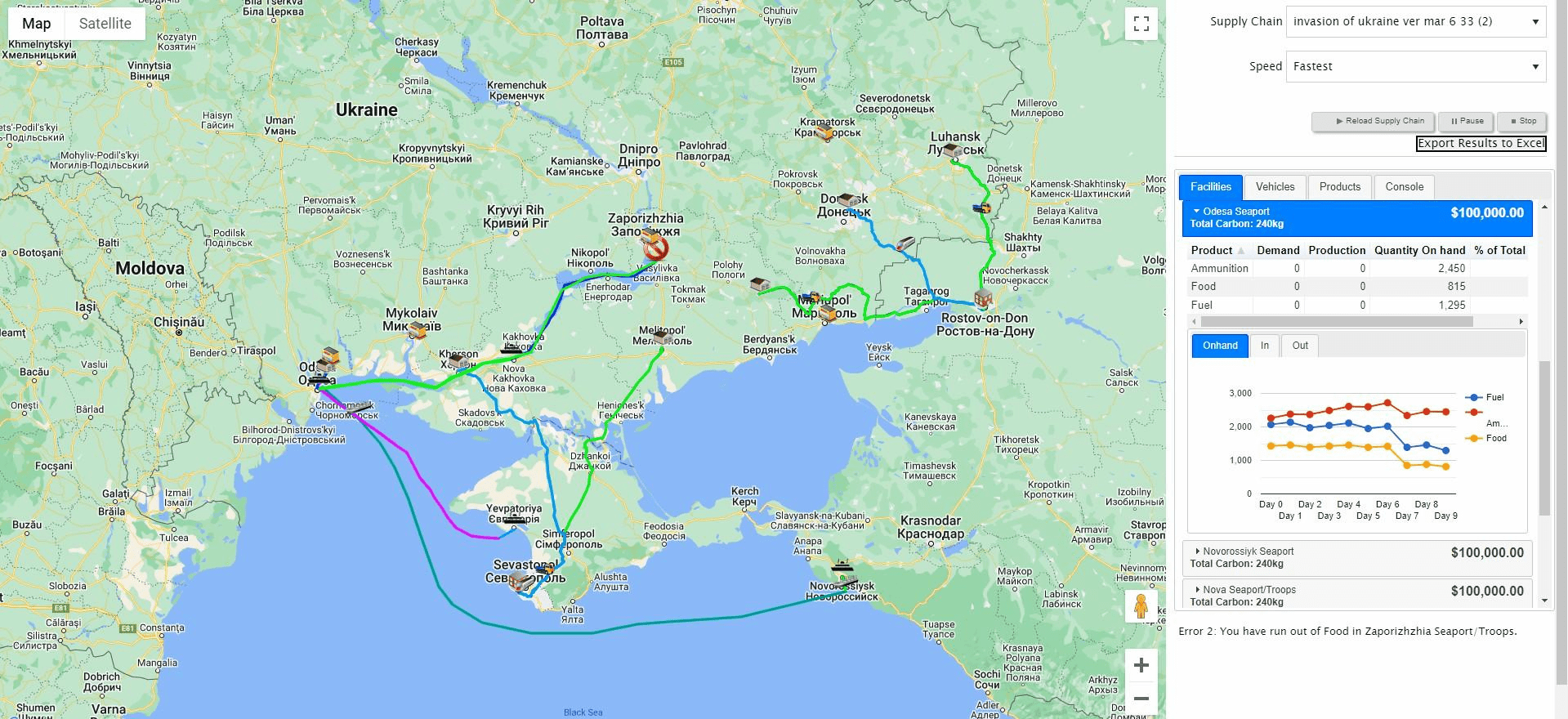 Figure 3. Simulation results from Scenario 3—Annex the South
The simulation results suggest that scenario 2 and scenario 3 are the most likely to succeed given logistics considerations. But scenario 3 requires the Russian capture of the Port of Odesa, which has proven difficult. So scenario 2, which supplies combat units mostly by rail, is the best choice logistically speaking. And indeed, that is the scenario the Russians have chosen to follow after their failure to take Kyiv and install a new regime.
As of early August 2022, this scenario appears to have failed as Russian combat units have not defeated the Ukrainian army. It seems that Russian logistics units could not deliver enough supplies to meet the daily needs of their combat units trying to take Ukraine’s capital. This logistics shortcoming also played out very clearly in the simulations. The key to making this scenario feasible was assuming the capture of major cities and secure rail lines. Otherwise, it fails.
In this scenario, supply chains are primarily truck-based because the Russian military’s ability to use railroads stops at the border cities of Ukraine, such as Kharkiv, which were still in Ukrainian hands. We based our estimates of the number and capacities of Russian supply trucks on data from the Twitter feed Convoy Thread. Our simulations indicated that Russian units lacked enough vehicles to deliver needed supplies to sustain military operations, especially if the simulations factor in attrition of transportation resources due to attacks on supply convoys. The simulations did not account for wear and tear beyond vehicular combat losses. Simulation results for this scenario clearly show this logistics plan will fail even though transportation capacity was modeled optimistically.
Much of the Ukrainian highway network is composed of narrow roads winding through forests and small towns, with bridges crossing rivers and streams along the way. In a scenario where the Ukrainian military does not collapse and the civilian population does not cooperate with the Russian invaders, the majority of these routes, running through hostile territory, are relatively easy to disrupt. Also, most LOCs from railhead to receiving unit or supply depot approached or exceeded 160 kilometers. As a result, the supply lines are long enough that trucks can only make about one trip per day.
In this scenario, Russia attempted airborne operations to open up airlift resupply options. However, the significant number of man-portable air defense systems (MANPADS) and other types of air defense systems make air operations within the contested territory very risky, and that risk was realized during the initial weeks of the war. So, in the real world, airlift lines of supply never materialized or made a difference, and one commenter even credited the lack of seizing airfields around the capital as part of the failure of the operation.
This scenario is the most likely of the four to succeed from our simulation’s perspective and appears to be the current Russian plan in Ukraine. Russian supply chains in these regions can more effectively use railroads because Crimea and large parts of the Luhansk and Donetsk oblasts are already in Russian hands. This enables high volume and relatively high speed of delivery. Trucks are used only for the last part of the chain, and their delivery routes are less than 160 kilometers. Russia can also make use of ships, which is efficient for delivering large volumes of supplies, on the Sea of Azov, which it started doing in April.
In this scenario, Russia has a better chance of maintaining land superiority over the territory through which supplies must move because it occupied the territory in the early days of the current invasion, and has done so by proxy since 2014. However, Ukrainians have shown they are able to hit logistics targets in Ukraine and Russia (e.g., the Berdyansk strike). Also, in the early days of the war, the shores around Crimea and the Sea of Azov were mostly out of range of antiship weapons available to Ukraine, but new weapons , depending on the Harpoon variants available to Ukraine, could put this into question. The Russian military certainly has the necessary trains and likely possesses the necessary ships and trucks for this supply chain to work. These logistics considerations make this scenario the one most likely to succeed, particularly when modeling Russian supply lines earlier in the war, prior to the introduction of Western artillery systems.
Scenario 3: Annex the South and Control Black Sea Access
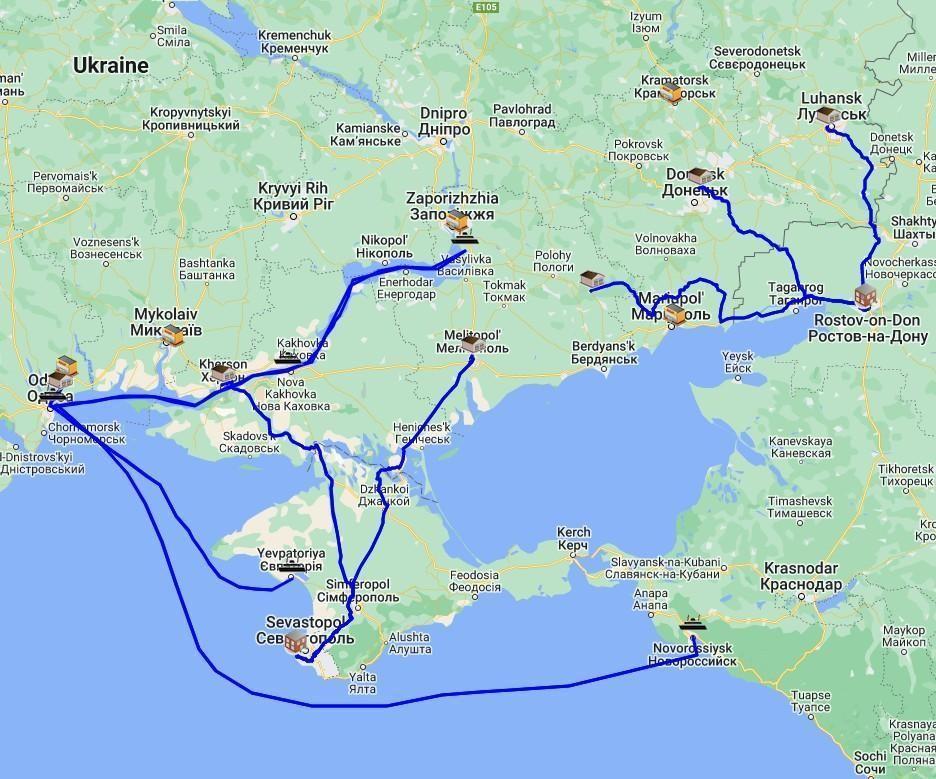 Figure 6. Supply chains to support capture of Odesa and southern coasts
Like the previous scenario, this approach mostly uses ships and railroads, enabling high volume and relatively high speed of supply. Again, trucks are used only for the last segment and their delivery routes would be less than 160 kilometers.
This scenario hinges on capturing the Port of Odesa. That would be accomplished by Russian forces in Kherson advancing on Odesa in coordination with amphibious forces also attacking Odesa. There are also limited rail routes to Kherson from Sevastopol. The main one includes a number of bridges, including the Antonivskyi Railroad Bridge, creating a choke point that can be exploited by Ukrainian forces. To secure their rail supply line, Russian forces would need to occupy territory at least ninety kilometers to the north, east, and west of Kherson.
Russian forces would capture Mykolaiv and then advance on Odesa. They would be supplied by trucks from the Kherson railhead. The shortest major road route to Odesa is the M14, which runs about 117 kilometers from the center of Mykolaiv to the outskirts of Odesa. While this route is less than the critical 160-kilometer threshold, the convoys taking it offer relatively easy targets, particularly if the area surrounding the roads cannot be cleared and kept secure.
The maritime approaches to Odesa are most likely covered by Ukrainian antiship missiles. Russian ships in the Dniprovs’ka Gulf on the way to Kherson and Mykolaiv would offer opportunities for engagement with various new antiship missiles that Ukraine has acquired. Furthermore, Ukrainian antitank guided missiles could be used if Russian ships ventured between three and five kilometers of the shore or watercraft. Russian amphibious forces in this scenario would need the support of land forces attacking from Kherson and Mykolaiv in order to overcome these challenges.
The points discussed above indicate Russian combat units probably cannot capture Odesa, which is key to making this logistical strategy work. While Russian logistics bases in Russia and Crimea could support early stages of operations in this scenario, Ukraine could sever these supply lines through its growing defensive operations along the coast and threaten supply lines on the road to Odesa. Unlike the second scenario, we assessed that railroad infrastructure and trains, plus harbors and ships, will be at greater risk because Ukraine will recognize that these elements are the keys to disrupting this supply chain, and Ukraine possesses the means to disrupt them.
Scenario 4: Divide Ukraine and Annex the East
 Figure 7. Supply chains to support capture of eastern half of Ukraine
Like the first scenario, scenario 4 relies too heavily on truck-based supply chains running through hostile territory in eastern Ukraine. The Russian army cannot sustain its combat units to support this course of action. To be successful, this scenario would either have to meet minimal resistance during the advance to the Dnipro River, or be executed as a grinding, phased campaign. This scenario would face the same logistics challenges as the other scenarios. Thus it faces the same risks and is unlikely to succeed.
Moving Forward: Winning on Contested Logistics
Since all campaign plans depend on certain key assumptions, logistics models should accompany plans, display potential vulnerabilities, and make it easy to investigate operational risks if some key assumptions turn out to be false. Campaign plans define starting locations for supply depots and combat units, and the locations of facilities they intend to occupy as a campaign progresses. The logistics model for a campaign plan shows what combination of vehicles and supply routes should be used to support combat operations through the duration of the campaign.
Map-based logistics models, like the one used in our simulation, show where facilities are located and show the vehicles and routes available to move products between facilities to meet demand. Running the model in map-based simulations makes it easy for a wide audience to understand the logistics requirements called for by a given scenario. This makes it possible to accurately assess the likelihood of success for each scenario and improve the decision-making process for the commander.a
No comments:
Post a Comment