DR NITHIYANANDAM YOGESWARAN
1. Introduction
Border settlements, a tactic frequently used in territorial disputes, have often been discussed in the context of China’s developments along the Line of Actual Control (LAC) with India. However, this strategy is not exclusive to this region and has been observed in other disputed areas in Georgia, the Arctic, and Antarctica. The history, cultural diversity, and modern geopolitical considerations surrounding border settlements’ evolution and strategic significance make for a fascinating and multifaceted narrative.
Border settlements have existed for centuries and emerged along ancient trade routes, pilgrimage paths, and strategic locations. They were established by various groups, including indigenous communities, rulers, merchants, and religious leaders, during different historical periods. These settlements played a vital role in defense and communication, serving as early warning systems against invasions. They also facilitated cross-border trade, cultural exchanges, and diplomatic interactions. As time passed, these settlements became melting pots of diverse cultures, hosting people from different ethnic backgrounds, languages, and traditions. This cultural diversity is reflected in each village’s unique folklore, festivals, and rituals.
1.1 China’s border settlements
Rapid construction activities, especially settlements in recent times, have occurred for various reasons related to its disputed territorial claims with neighboring countries. While the Chinese Communist Party initially presented these settlements as part of its poverty alleviation campaign, they also played an essential role in national security. The settlements are established to strengthen surveillance and security, assert territorial claims, maintain a civilian presence as a deterrent, support military operations, encourage Chinese citizens to work in ethnic minority populations, and promote economic development in remote areas.
The rapid construction of these settlements, including large housing blocks and people’s relocation to these areas, has been most significant in the Tibet Autonomous Region. This has led to a swift expansion of China’s presence in the disputed regions. Furthermore, these settlements have been used to negotiate disputed regions, further reinforcing China’s territorial claims.
1.2 The Land Border’s Law – A booster
The Land Borders Law of the People’s Republic of China, enacted in October 2021, is considered a significant step towards establishing new settlements on the border. This law highlights China’s approach to its border regions, focusing on defence and security. It specifies the division of responsibilities among various bureaucracies, authorises the use of force, emphasises the role of citizens and civilian institutions in border defence, outlines conditions for emergency measures, and pledges state support for socio-economic development in border areas.
1.3 What is unique about this article?
The media often reports on the emergence of new villages near borders, but these settlements lack detailed mapping and spatial context. Our research aims to identify smaller settlements near the border and larger settlements with a dual purpose across the entire area of interest (i.e. 100km from the border of four districts of Arunachal Pradesh). This article focuses on newly established settlements within or near existing towns or areas with available resources. These settlements are placed to gain military advantage or to tap into local resources.
We have used advanced remote sensing tools, such as satellite imagery and remote sensing algorithms, that detect even minor settlements in these regions to map these locations accurately. This method allows for a more precise and detailed settlement mapping to study its spatial pattern.
For this study, we have selected a few examples to understand the subject better and give insight into broader patterns and trends of settlement development in border areas.
2. Mapping and spatial analysis of Chinese settlements located within 100km range from the four districts of India’s Arunachal Pradesh


This analysis maps settlements approximately 100 km from the India-China borderline, utilising advanced remote sensing technology. Unlike traditional studies that only focus on smaller settlements, this research aims to identify larger settlements that exceed the size of 0.25 sq. km, which have been determined using coarse resolution non-optical remote sensing data. The study focuses specifically on settlements around 100 km from the LAC, along the four Northern districts of Arunachal Pradesh, starting from Tawang to Kurung Kumey.
Furthermore, the analysis examines the identified locations using moderate and high-resolution optical remote sensing datasets. This in-depth examination aims to provide an understanding of the settlements in the region, including their size, location, and characteristics.
The research findings indicate two significant clusters of settlements, marked by yellow dotted lines on the map. Our research investigates each location, providing valuable insights into the settlements’ nature, proximity to critical features, and the types of civilian and military developments within them. Additionally, the study examines common traits and potential growth trends in the region.

One of the most significan patterns that emerges from the research is the proximity of major settlements to highways and water bodies. This indicates that two predominant characteristics are shared across these dispersed locations, as evident from the heat map above. Further analysis suggests that this clustering of settlements around road networks and water sources will likely continue, as these factors remain essential for developing and growing settlements.
2.1 Significant developments
Out of the original 35 identified settlements, we picked settlements with strategic importance and dual-purpose structures for discussion in this article.

A new residential development has emerged along the banks of Loro Chou, near the G219 highway at Chayal, approximately 12 km from the Line of Actual Control (LAC). This area features a newly constructed settlement near a small dam on the Loro Chu stream, consisting of over 100 border defence houses, covering an area of about 0.043 sq. km.

Additionally, there has been significant redevelopment in an older settlement near Jamchen, which now includes more than 75 structures, encompassing an area of 0.052 sq. km.
Both these developments, including the new and redeveloped settlements, materialised between 2019 and 2020. During 2020, the area underwent further enhancements, including adding various recreational facilities. These new settlements complement the numerous existing ones scattered across the region.
The area lacks substantial military infrastructure, except for two helipads near the newly built houses. These developments indicate a significant focus on regional residential expansion and infrastructure enhancement.
2.1.2 Settlement 02 – Cona County
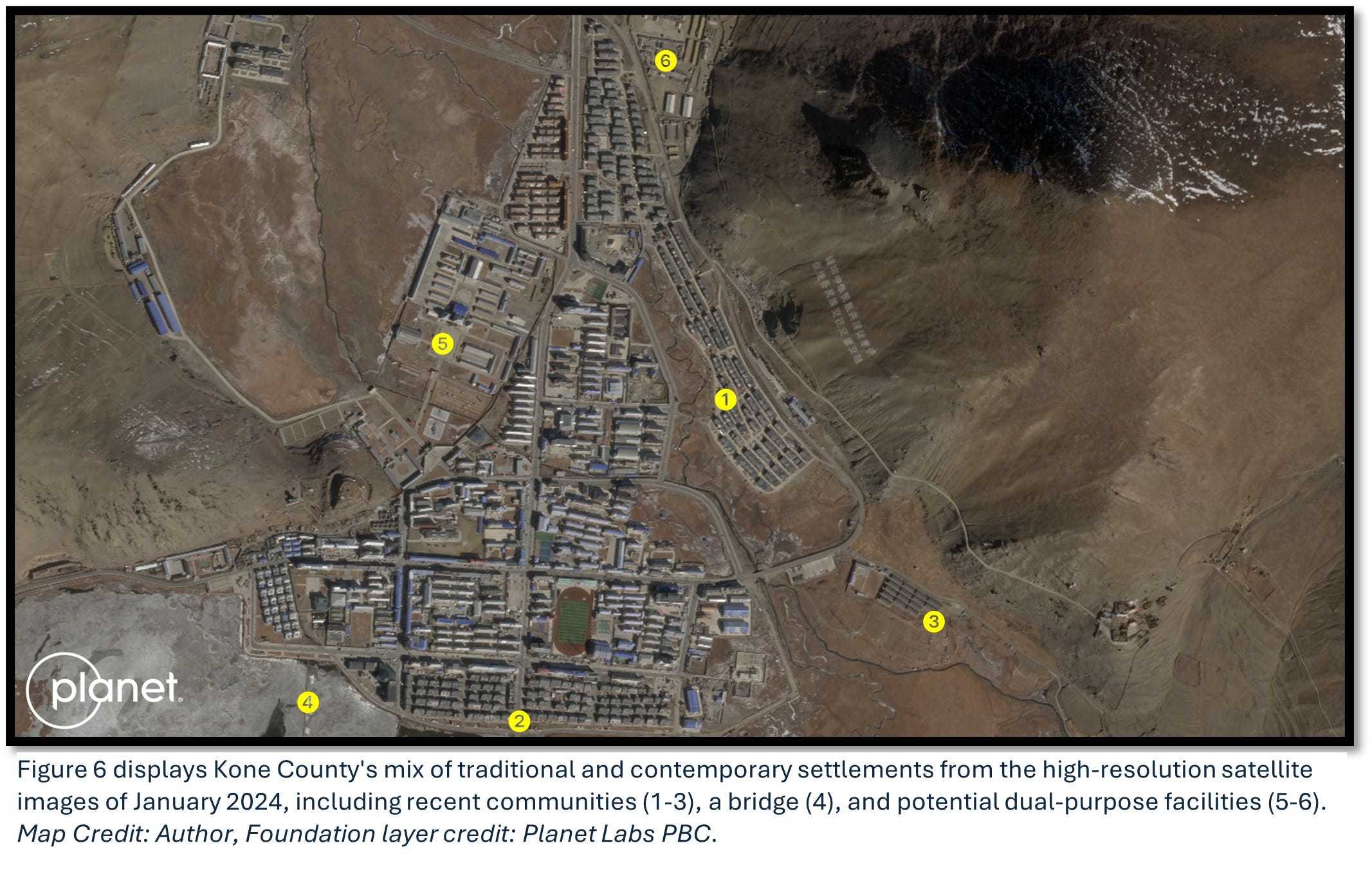
Kone County is a historic and sizable town located in the southern part of Tibet. It is surrounded by mountains, situated 25 km from the LAC, next to Highway S202, and shares its border with Bhutan.
Kone County has a rich history and has experienced significant developments since 2018. From 2019 to 2022, there has been a notable shift in settlement patterns, with new residential areas established similar to those in other regions. Between 2020 and 2021, an extra site was also found, further expanding the town’s footprint.
The area has seen substantial redevelopment initiatives, including operational reservoirs established in 2020. The town has a robust military presence, as evidenced by its infrastructure, which includes military vehicles and helipads strategically positioned on the northern, eastern, and western sides.
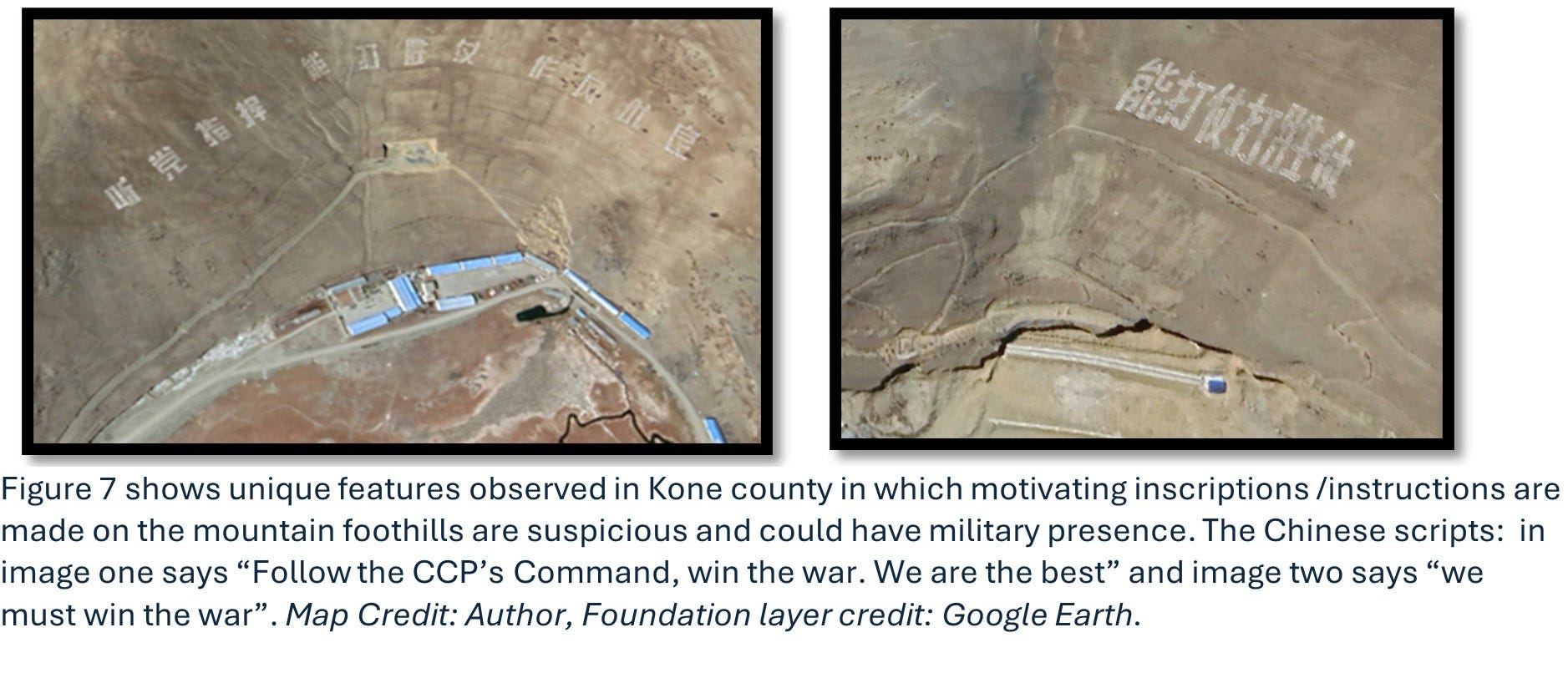
The large inscriptions with messages cascading down the mountain slopes are particularly interesting. These structures serve a dual purpose: to symbolise the town’s military significance and act as a beacon, encouraging the local populace to adhere to the directives of Chinese leadership. It is also noted at places, these inscriptions are removed or, at times, replaced with new ones. As Kone County grows, it extends along the valley in the northern and southern directions, highlighting its historical importance and contemporary geopolitical dynamics.
2.1.3 Settlement 15 – Raorang

In our series of site explorations, Rorong Settlement was the 15th one. Nestled between mountains, this settlement thrives along the banks of the Char Chow River. Rorong came into being in mere months between May 2022 and January 2023.
The settlement has the advantage of a well-developed road network established at the same time as the settlement. These roads are helpful for the local community and extend 6 km downhill towards the LAC. The settlement itself is located 12 km from this line.
A small unit with 13 blocks roofed in red near the settlement was established in August 2023. Additionally, some administrative buildings are situated on the sideline of the mountain. Some administrative buildings are placed atop the mountain’s sideline.
Notably, the Rorong Settlement is situated in a valley around 3000 m above sea level, in contrast to the nearby mountain peaks of LAC, which range from 4000 to 5000 m. This positioning renders the settlement less visible from the surrounding mountaintops. Ongoing development has been extending downhill towards the Line of Actual Control. This includes the emergence of new, smaller settlements or structures and land clearing for agricultural purposes.
One particular instance of this development is the placement of 10 shelters, likely for agricultural use, about 2.7 km from Rorong. This structure was established between March 17th and 19th, 2023, near Xian Gqu. Consequently, the expansion of roads and other minor activities continue to progress in this valley, moving closer to the LAC.
2.1.4 Settlement 17 – Migyitun


Since 1950, the region of Migyitun and its nearby areas have been a subject of contention. Notably, Chinese control in the valley has significantly increased since 2020. Figures 10-12 depict the current state of developments at three specific locations around Migyitun. Moreover, our earlier publication comprehensively discussed settlement number 17, identified as Zone B.
2.1.5 Settlement 22 – Gyaca

After examining site number 22, we have discovered that it is an age-old settlement alongside the Yarlung Song Po River. The site provides a unique perspective, distinguishing between formal and informal settlements. Legal settlements, which are highly versatile, are found on one side of the riverbank, while informal settlements are predominantly located on the northern bank. Furthermore, the western areas of the site host more formal structures, which indicate the settlement’s diverse nature.
Over the years, the site’s infrastructure has expanded significantly with new bridges and improved facilities. Despite this, Highway S306, which passes through the site, has remained unchanged from 2021 to 2023. Before the pandemic, the site had experienced considerable development, with numerous small sites emerging. These developments, located several kilometres from the border, are believed to serve not only military purposes. Establishing such sites will facilitate a physical presence, leveraging local human resources and materials for significant projects such as dam construction and water management in the upstream areas.
2.1.6 Settlement 33 – Near Longda

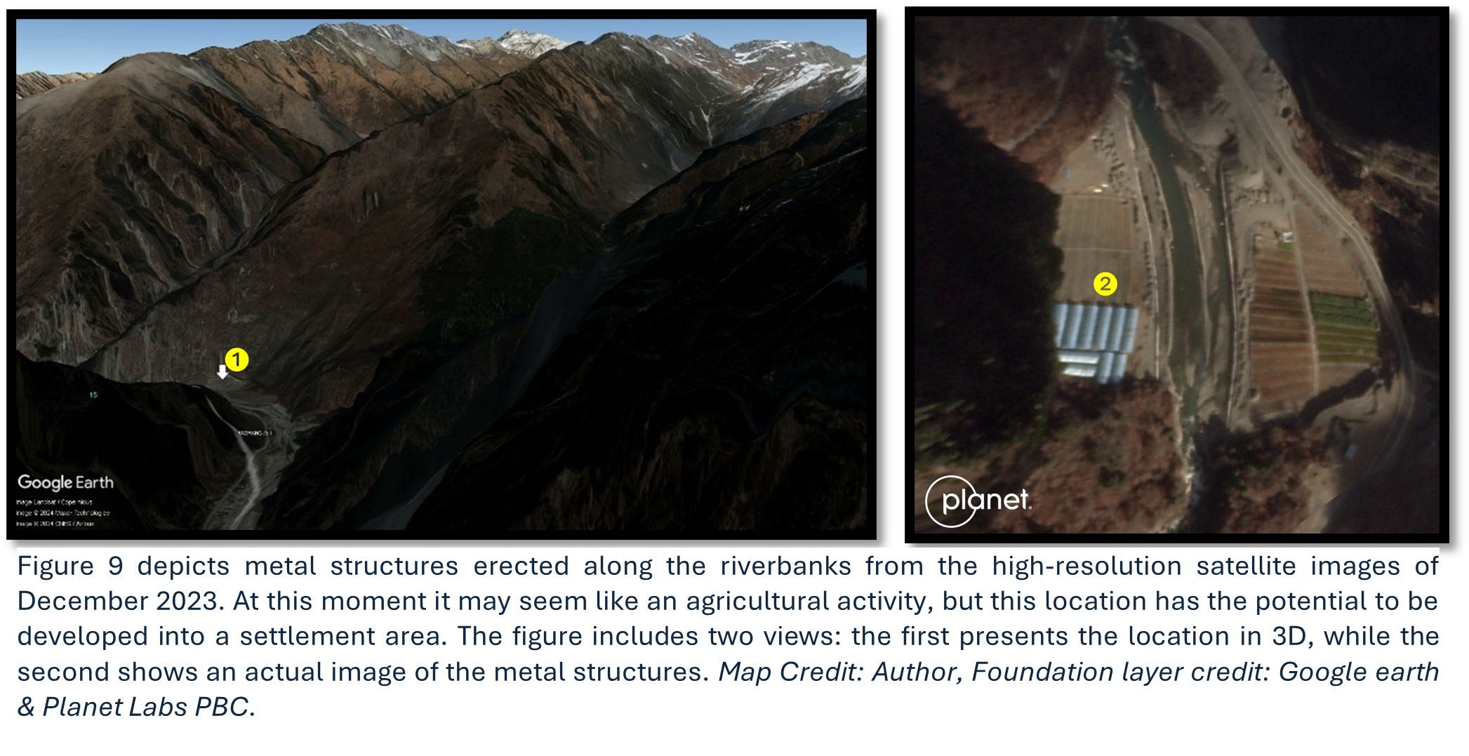
Site number 33, positioned along the northern banks of the formidable Yarlung Tsang Po, presents a fascinating case in our study. This location is characterised by its dispersed settlements interspersed with elements of military-like infrastructure. A notable feature is one of our newly identified structures along the riverbank. This area has seen a development progression, beginning 15 years ago, with significant redevelopment occurring more recently along the border.
A key observation across the riverbank is the presence of approximately 25 building structures, each accompanied by antennas - a striking difference from the other side. Over time, these structures have increased, and associated administrative buildings have also been augmented. Additionally, recent images from 2024 reveal the emergence of new metallic structures in this area.
Figure 13 presents a temporary metal structure that was evident in the initial image from November 2019 but had disappeared by the time of the second image in Dec 2023. Map Credit: Author, Foundation layer credit: Google Earth & Planet Labs PBC.
The exact nature of these developments remains ambiguous. While distinct from typical civilian constructions, it is unclear whether they serve a military purpose. They could be related to civilian police operations, other security activities, or testing endeavours.

In a unique observation, we’ve noticed that the structures at this site tend to be clustered together. A large, potentially metallic structure previously situated along the riverbank and atop a mountain is fascinating. This structure was notably removed, and the area where it stood was filled and covered with soil. The specific reasons for this action and the current status of the structure remain unclear.
It’s important to note that this structure was well-integrated with the existing road network, suggesting it might have been used temporarily. This could include serving as a facility for construction projects or other short-term activities and then being dismantled once its use is concluded. However, based on satellite imagery alone, this structure’s exact nature and purpose remain indeterminate.
2.1.7 Settlement 30 – the latest Shannan Longzi Airport

The historical satellite images present the temporal activities of the newly built Shannan Longzi Airport, located less than 50 km from the LAC at an altitude of 3,900 m. This airport features a 4.5 km-long runway and has been under construction since 2021. Satellite imagery analysis reveals that significant land clearing was done to make way for this project. Subsequent images from 2022 and 2023 show the development of an airbase complete with essential support systems. It is unclear at this point whether the airport’s infrastructure will be solely dedicated to military use or serve a dual purpose. Considering the pattern observed from other airbases around the region, we can confidently state that major settlements will emerge around this airbase. Likely, every flat piece of land adjacent to or connected to this place via road or railway will be transformed into a concrete settlement.
2.1.8 Other settlements – along the Yarlung Tsang Po

The figure above shows the diverse settlements along the Yarlung Tsang Po River. These settlements, a combination of old and new, are dispersed along the river, with some being prominent, structured settlements. They share similarities in shape and characteristics with other border defence settlements. The development of these areas has been gradually increasing, driven by the region’s rich potential resources. The area’s abundant solar energy, ample water supply for hydroelectric power, and road access make it exceptionally valuable.
The riverbanks are adorned with flat, fertile lands, instrumental in these areas’ continuous occupation and habitation. Settlements aim to establish a physical presence in strategic locations. They vary in size and sophistication, ranging from simple hut communities to modern villages and even towns, depending on the available land and opportunities the inhabitants exploit.
One of the most striking features of these settlements is that they often serve a dual purpose as both residential and strategic sites, distinct from other regional features. These settlements showcase a unique blend of resource utilisation and military importance, reflecting the dynamic growth and evolution of the area along the Yarlung Tsang Po River.
2.2 An unnamed border settlement

Located about 15km south of Mailing, an unmarked border settlement on the western side of the Milin River, which flows into the Yarlung Tsang Po, is located. Close to the disputed boundary, a small, desolate area covering 0.11 sq. km is situated. This land, previously barren for many years, has recently transformed into a border settlement. For an in-depth analysis of this settlement, please refer to our previous article, where it is designated as Zone A.
2.3 Spatial distribution of Monastery and dual-purpose settlements

From the above map, we can observe the spatial characteristics of local settlements, particularly their proximity to water bodies and roads. We conducted an exercise to explore the spatial relationship between these settlements and the historic Monastery. Our investigation aimed to understand whether these settlements have developed in adjacency to the Monastery, known for its strategic location near water sources, or have evolved independently with distinct purposes, possibly for optimising resource utilisation and serving multiple functions.
Our findings are illustrated on a map highlighting monasteries’ locations traditionally established near water bodies. Interestingly, newer settlements follow this pattern of adjacent water sources. These settlements are not expansions of the areas around the Monastery sites, which are typically associated with towns and small villages. Instead, they are emerging in new locations, often closer to borders in strategically important areas, potentially offering military advantages.
The map demonstrates the strategic intent behind establishing these water-adjacent villages. Through this, one can deduce the emergence and characteristics of these settlements, providing valuable insights into their development and purpose.
3. Parting shot
Our study explored a range of settlements, including those of significant size serving dual purposes and more minor, strategically located settlements. A development trend is observed predominantly along border areas, often near valuable resources. These developments are not merely incidental but deliberately designed to be all-weather, resilient structures that can serve military purposes. These settlements sometimes represent new construction projects involving clearing land and vegetation. In other cases, they signify redevelopment efforts where old structures are replaced with new, formal constructions.
These border settlements have unique spatial patterns and architectural characteristics that differentiate them from other settlements. These features are essential in identifying the border villages and the dual-purpose and military settlements. The latter are often surrounded by boundary walls and closed-circuit surveillance, distinguishing them from nearby civilian settlements that tend to be more dispersed and unstructured. Rivers and other physical features naturally mark these dual-purpose settlements, distinct from typical urban expansions. Based on time series satellite images, most construction work occurs during June and July when weather conditions are mild.
It is crucial to monitor these developments closely. Analysing the settlement patterns suggests a deliberate strategy to occupy all viable land, regardless of size, especially if it is flat, near a water body, or adjacent to roads. This expansion often occurs near historical monasteries, influencing the surrounding area. However, sometimes, the location choices are based on strategic considerations.
Remote sensing analysis, complementing human intelligence, is pivotal in this research. The use of moderate-resolution satellite sensors has been particularly highlighted. Our study has mapped several large and small settlements in open areas and shadowed regions. In our newsletter, we will continue covering the border settlements along the LAC with the other districts of Arunachal Pradesh and parts of Tibet. Our ongoing research is poised to reveal intriguing findings and insights related to this topic in future articles.
No comments:
Post a Comment