


DR NITHIYANANDAM
Recent developments have shed light on China's military readiness as tensions rise between China and India on border issues. For the past few years, China has been increasing the deployment of military radars in Tibet, both permanent and mobile installations, to strengthen the first line of defence. In this article, we have studied the satellite-based Synthetic Aperture Radar (SAR) imagery and mapped out the locations of these radar systems on the ground using an open-source tool. We also analysed the radar footprints' spatial and temporal aspects, providing a detailed understanding of China's strategic position in Tibet. These findings are crucial in comprehending the current situation in the region and have potential implications for India’s combat readiness.
Role of the Radar in modern-day Military
In the present era, military systems have increasingly relied on deploying radar installations to achieve critical capabilities in various areas such as surveillance, reconnaissance, target detection, tracking, and situational awareness. These capabilities are essential for adequate defence, intelligence gathering, and strategic decision-making and play an integral role in safeguarding national security interests.
Though there are multiple applications of radar, we have picked some specific ones relevant to the current study as follows:
a. Missile Defence - The significance of early warning radars cannot be overstated when detecting, tracking, and intercepting inbound missiles. These advanced systems are critical in granting vital seconds to react to missile threats and take proactive measures to prevent potential harm or damage.
b. Surveillance and Detection: Radar systems can constantly monitor vast territories and airspaces to detect and identify potential threats. These systems can effortlessly detect various objects, such as aircraft, missiles, or ships, even in rough weather conditions or poor visibility, ensuring the area's safety under surveillance.
c. Electronic warfare: In electronic warfare, radar installations serve the purpose of detecting, identifying, and countering enemy radar signals and communication systems.
d. Air Traffic Control (ATC) and Management: The significance of radars in the control and management of aircraft cannot be minimised, both in civilian and military contexts. These sophisticated systems play an indispensable role in ensuring air travel safety by enabling the detection and avoidance of potential collisions, thereby minimising the risk of accidents. Whether it's tracking the movement of nearby aircraft or identifying potential hazards such as weather patterns or obstacles, radars are a crucial tool for pilots and air traffic controllers.
In short, a nation-state that possesses highly developed radar technologies to track both its territory and that of its adversaries gains an operation edge in warfare.
In the following section, we will share our approach to identifying military radar sites in Tibet and gaining deeper insights by studying the surveillance period, the radar's extent, and spatial context.
Mapping military radars
In February 2022, Ollie Ballinger, a lecturer at the Centre for Advanced Spatial Analysis at University College London, developed the radar interference tracker. This was based on the discovery made by Harel Dan, an Israeli Geospatial Engineer, in 2018. The pattern resulting from radio frequency interference between the space-based and ground-based radar systems was inferred using the radar interference tracker.
For this analysis, Spaceborne Sentinel-1
1 SAR images are utilised. These images are different from optical high-resolution satellite images. Visual images are passive and show features in similar colours as visible to humans. In contrast, SAR is an active system where the sensor transmits energy with a specific frequency and records the intensity of backscattered radiation in decibels (dB)
2 in different polarisations.
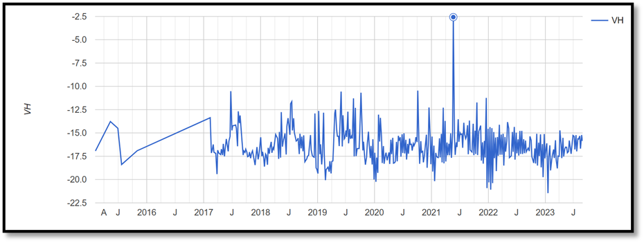
In Figure 1, variations can be seen in the backscattered values on the Sentinel-1 image recorded at VH polarisation. A sudden spike observed in May 2021 suggests the presence of other radar waves.
The variation in dB values depends on the surface feature, with all terrains having minor variations in backscattered energy. The surface material, soil moisture, and roughness largely control the interpretation. However, erratic spikes can be caused by severe interference of signals on the ground, which could be from another high-frequency radar system operating at the same frequency.
The deployment of military radars can create an interference pattern that is distinguishable in Sentinel-1 images after several processes. This pattern forms distinct, evenly spaced stripes that are not to be confused with other forms of artefacts, such as blips, speckles, or waves that varying conditions can cause. Our team conducted a thorough analysis of Sentinel-1 images from 2016 to the present and discovered the presence of red spikes that indicate the frequency of the emitted pulses. In cases where multiple spikes are visible within the same area, numerous observations were made, possibly when the radars were turned on. Despite this procedure being a proper observation method, it has certain limitations. For instance, it can interfere with ground radars that operate at the same frequency and those turned on during the satellite overpass. It is essential to note that Sentinel-1 images can cover the exact location every six days in most areas, with 1A & 1B pair satellites, and 14 days in regions lacking them.
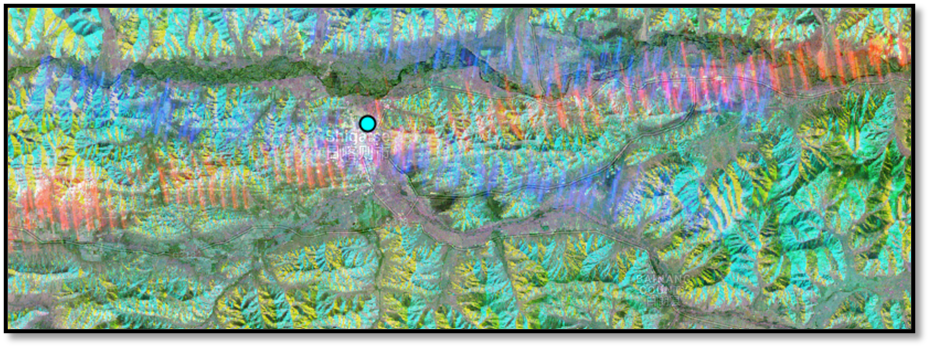
Figure 2 shows the interference pattern formed in relation to the pairs of satellites Sentinel 1A and 1B with respect to a ground-based radar.
When observing backscattered microwaves in both Sentinel 1A & 1B, areas with red and blue cross stripes may indicate the presence of a Military radar, with the center point of the cross being the likely location.
Military radar activity in the Tibet region
Due to escalating political and military tensions, China has heavily fortified the region with robust military radar systems to monitor major conflict zones, including the LAC, to show their readiness towards any potential threat from India. Over the years, radar monitoring has consistently intensified, with mobile systems being replaced by permanent monitoring stations equipped with high-powered radars in critical areas. The altitude of the radar varies depending on the area being monitored and coverage requirements. Radar may be placed at a lower height where viewshed regions are to be monitored or when the intention is to protect hidden assets. However, some radar signals are picked up at strange locations far away from human settlements and the contested Indo-China border, nullifying the purpose of monitoring critical infrastructure or enemy intrusion.
Occasionally, radar signals are detected instead of the usual radar spikes, suggesting that a site may not be a typical monitoring station. However, this interference is caused by activating an antimissile radar system during military exercises or troop movements along the road.
There have been repeated sightings of strong signals over some mysterious regions, which may indicate an attempt to protect strategic weapons hidden in those locations. Detecting military radar signals in areas with no apparent physical infrastructure is puzzling.
Let's take a closer look at the traits of military radar signals. We'll examine their spatial features that show variations in intensity and time
3. Considering the topic's sensitivity, precise coordinates are not provided, and maps are not drawn to scale.
a. Pangong Tso Lake
Pangong Tso is a high-altitude lake located on the border between India and China. In 2020, Chinese troops attempted to intrude into the lake's southern bank with "proactive military movements”.
Based on our observations, the Southbank area has been consistently monitored, with the highest interference levels occurring between July and November of 2018. We've identified three specific spots that seem to intersect with Highway G219, two of which are monitored regularly. This highway is a significant infrastructure project established by China near the Indian border.
Upon closer inspection of high-resolution images, we noticed a Surface Air Missile (SAM) site near the southern bank. Given its proximity to the national highway G219, it's likely that the interference is caused by a radar beam emitted from the mobile Chinese antimissile system in the area. The fact that we've consistently observed these interferences thus far suggests that the region is being monitored regularly.
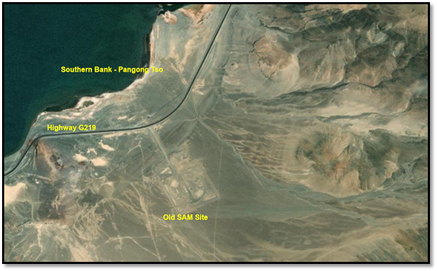
Figure 3 displays a high-resolution image of the part of Southern Bank of Pangong Tso and nearby road infrastructure. Source: Esri, Maxar, Earthstar Geographics, and the GIS User Community
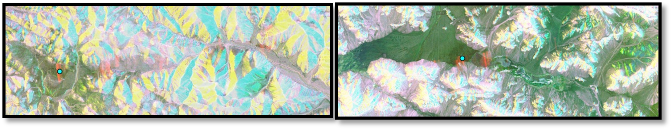
Two radar interference patterns are shown in Figure 4, observed over Pangong Tso Lake and adjacent valleys. The red lines indicate radar interference, while the blue dots show potential radar point sources.
b. Aksai Chin
During our analysis, we've identified three vital radar interference spots in this region. One is located close to Aksai Chin Kul Lake and cuts across the Aksai Chin River. Another is between Gozha Co and Orba Co lakes, near Yesh Hill Chu Valley and Kongka la highway. The third one is near Heishi Beihu Lake in the open valley. We've found multiple spikes since 2017, indicating severe regional radar interference. Different instances of interference indicate multiple ground-based radar systems operating at different times and locations. The radars appear to have been positioned to protect against unauthorised access and safeguard assets constructed or deployed in that vicinity, given that the evident interference patterns are noticeable.
Figure 5 The first image between the Ghoza Co & Orbaco Lakes shows multiple interferences of different time stamps. The highest peak was recorded during May 2021, with dB up to -4.02 units. Indeed, multiple small radar footprints are observed around the region. The second image of AKE SAIQIN was very active during 2019-2021.
c. Nagchu
Nagchu is a significant town in Tibet. It has a mixed infrastructure, civil and military facilities and is surrounded by mountains. The townhouses military installations include helicopter bases, radar stations, and other structures. It appears to be one of the few places with a permanent high-frequency radar established to monitor the area continuously. There was another interference detected above Nagchu, situated between the lakes. It was a rare occurrence and could be caused by a mobile radar system.
In Figure 6, radar interference was observed over Nagqu. The presence of multiple red stripes suggests that the interference was caused by Sentinel 1A's interaction with the powerful ground radar system, while the blue stripe indicates interference between Sentinel 1B and the ground radar. The intersection of the two stripes may indicate the location of the radar source

Figure 7 shows the location of the Radar station on the left and the potential phased array military radar on the right at Nagqu.
d. Lhasa
As the capital of the Tibet Autonomous Region, Lhasa holds great cultural, religious, historical, and geopolitical significance. The city is situated at an altitude of around 3700m and is surrounded by tall mountains. The town has a large civilian population, dense physical infrastructure, and a few military installations may exist.
Two major areas in the region experience radar interference. One is in the Lhasa He valley, while the other is located below it over the Yarlung Tsang Po River in Gong Gar County just before entering India. The radar interference can reach as high as -4.5 dB, with significant spikes observed in 2018 and 2021. It is suspected that the radar systems are being used to safeguard the urban and water infrastructure in the area.
Figure 8 displays radar interferences observed over Lhasa (top) and GongGar County (bottom), with multiple spikes indicating frequent high-frequency monitoring.
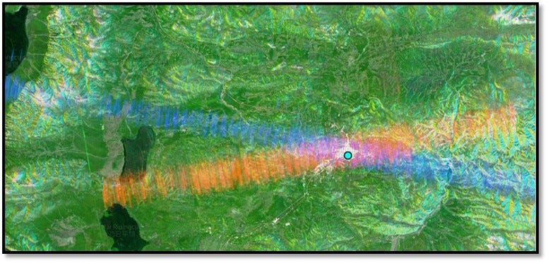
e. Shigatse
Shigatse is the second largest city in Tibet and is strategically located. It lies in the direct line of sight to India's Chicken Neck, which connects the Rest of India with north-eastern India. The city is also located on the mighty Yarlung Tsang Po. During our research in this region, we have observed two areas with radar interferences: one over the city of Shigatse and another over Gyantse County. The radar interferences observed over Shigatse covered a very long area, including its peace airport and city. Notably, the radar interference is quite strong over Shigatse, reaching above +1dB value, which may be unusual due to some other strong interferences. However, we have observed regular solid spikes over the region, indicating military radar in both areas. Shigatse's Peace Airport has a dual purpose for civilian and military use and is equipped with various military radar devices.
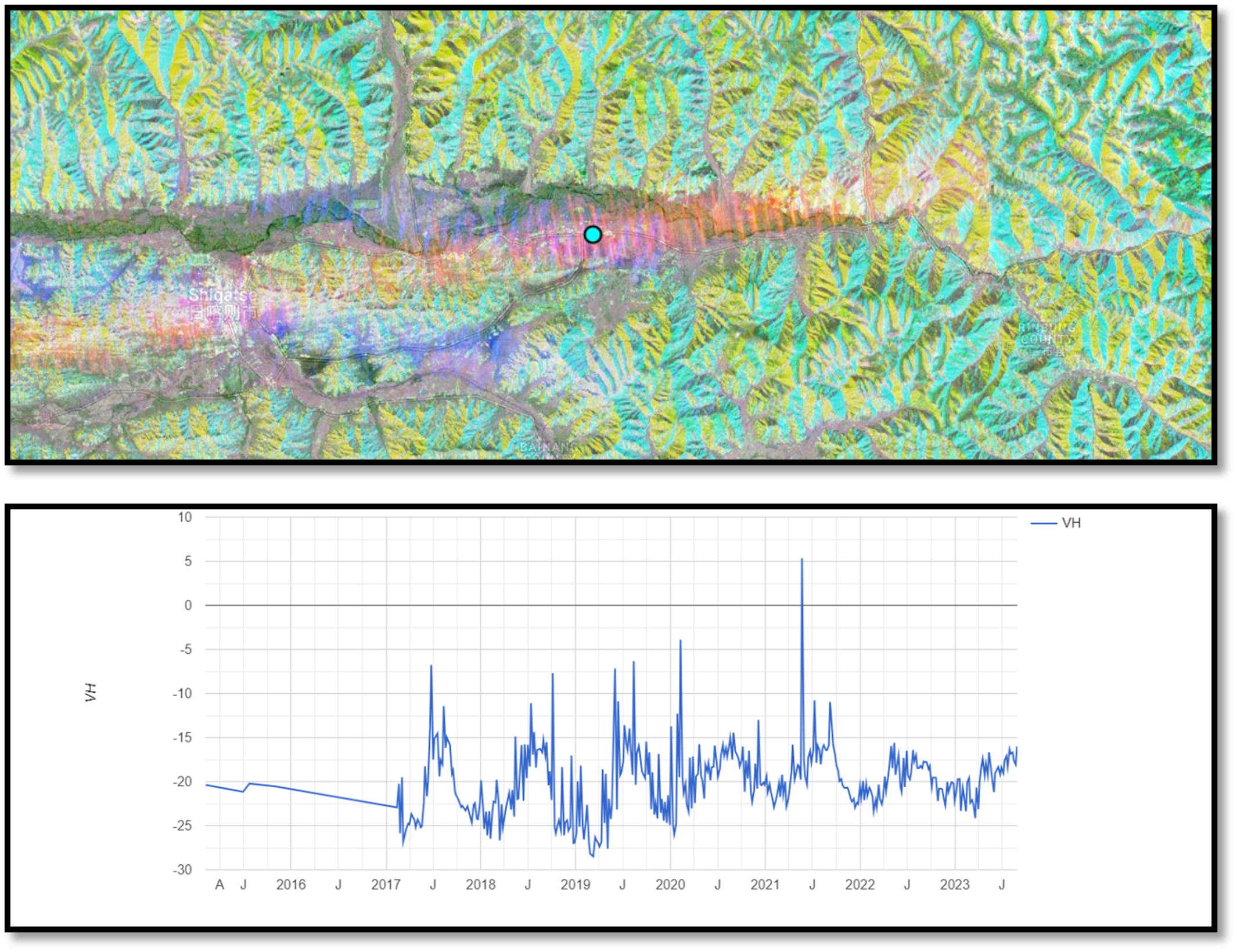
Figure 9 shows the interference pattern and intensity recorded over Shigatse City over time. In 2021, intensity reached 5dB for unknown reasons.
f. Yadong County
The Yadong County is a significant location in Tibet, situated near the borders of India, Nepal, and Bhutan. It shares boundaries with India's Sikkim state on the west and Bhutan on the south, making it a strategically sensitive region due to its proximity to these countries. Apart from being a vital trade route, the area is also ecologically sensitive.
Through our research, we have pinpointed two zones. One is intended to prevent intrusions from the Indian state of Sikkim, while the other is located on the opposite side of the border with Bhutan. The Sikkim zone was active twice during the winters of 2017 and 2022, with a higher frequency of up to -7 dB. Meanwhile, the area near Dochen Tso Lake, closer to the Bhutan border, has been active recently and operational since 2022.
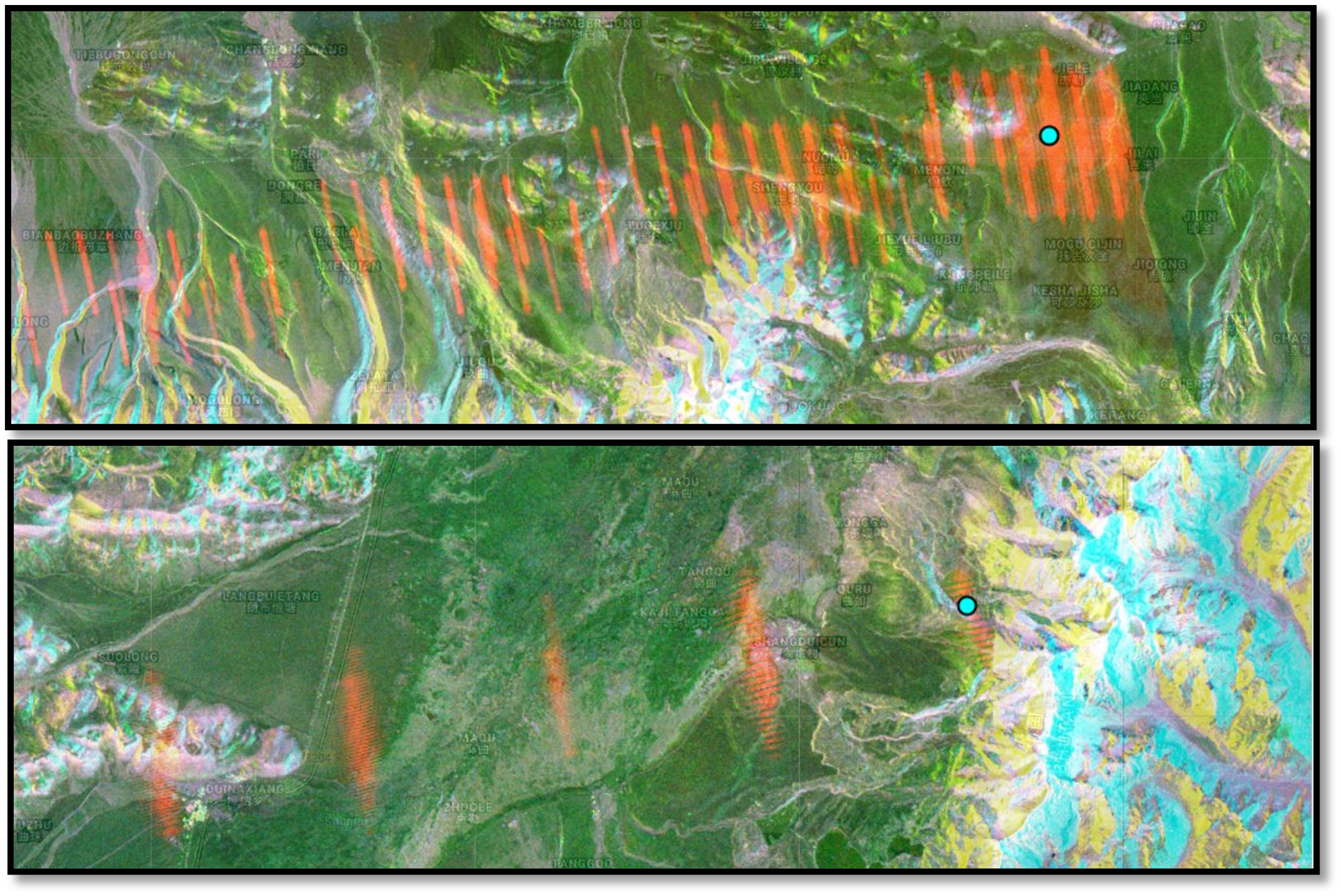
Figure 10 shows two areas on either side of Yalong County. The top image depicts the Chinese border with the Sikkim region, while the bottom image displays radar interference originating from the Bhutan-China border. This interference covers the region acting as a gate towards mainland China.
The critical radar interference locations are compiled in the map below:
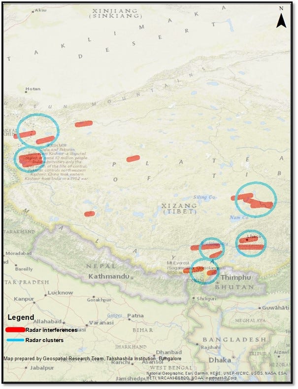
Figure 11 shows the key interference pattern observed over various parts of Tibet marked as red stripes and clusters of interferences marked as blue circles. The stripes are drawn broadly with respect to the actual coverage observed. However, the map is not to scale.
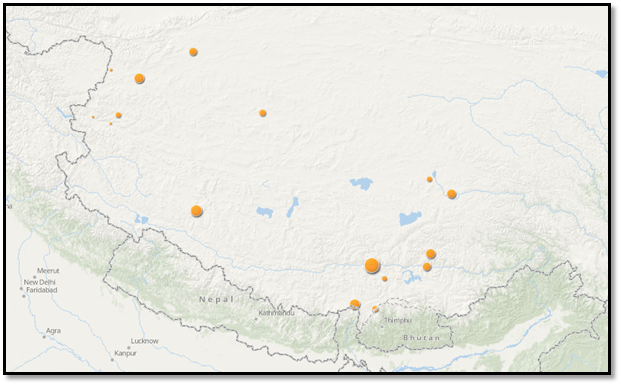
Figure 12 illustrates the intensity of a few military radars recorded in dB at a specific time, with the size representing their location.
Parting Shot
Chinese radars have maintained a consistent presence across regions marked by border disputes and sites of strategic military importance within their territory, utilising high-frequency operations. The radar interference range varies from 28 to 110 km, with most covering 70 to 85 km and some small inferences observed up to 28 to 40 km. Radar interference near Yadong County, close to India's border, uses high-frequency modulation techniques and reveals a narrower gap between pulses. This ongoing operational pattern serves as a testament to China's state of readiness while shedding light on its active strategies as discerned from the intensity and timing of activity.
Although the analysis is limited to a one to two-week time frame due to the satellite-based Synthetic Aperture Radar (SAR) system, it remains a crucial tool for operation assessment. Its open-source intelligence offers valuable insights into fingerprinting radars, adding to the arsenal of classical Radar Finger Printing Techniques. Our examination has led us to identify a radar with the characteristics of China's Type-381, operating in the G Band frequency.
While our analysis highlights clusters of interference patterns in select areas, it's worth noting that numerous smaller radar footprints exist but are not expounded upon here. It is worth noting that a substantial radar interference was detected near Heishi Bei Lake (roughly 300 kilometres from Aksai Chin in a direct line of sight), near the foothills of a mountain far from any civilian or military establishments. This incident raised suspicions of a concealed structure on the mountain slopes that could serve as an underground facility.
The efficacy of this technique extends beyond China's radars, having successfully mapped radars like the USA's Patriot, Japan's FCS-3, Sweden's STRIL, and Russia's S400. To fortify the credibility of our findings, we've diligently sifted through false positives, cross-referencing them with spatial entities and other contextual factors. Additionally, we've delved into scenarios where non-military radars might exhibit traits akin to military radars under certain conditions, corroborated by insights from weather radars and supplementary sources to prevent misleading results.
No comments:
Post a Comment