


DR NITHIYANANDAM
TL; DR
- China has made substantial investments in the Western Theatre Command, including constructing new airbases and heliports and improving existing infrastructure.
- Many of these airbases in Tibet and Xinjiang serve dual civilian and military purposes.
- China's rapid construction pace and utilisation of cutting-edge technology indicate its commitment to maintaining a long-term presence in the region.
- All military installations aim to be constructed with self-sufficient infrastructure and amenities.
- This study used high-resolution satellite images to analyse three operational dual-purpose airports and two airbases under construction in Central Tibet. Additional analysis will follow.
Since the confrontations between India and China in both 2017 and 2022, there has been a noticeable strengthening of China's People's Liberation Army Air Force (PLAAF) presence in the strategically important places of Tibet and Xinjiang provinces, which are situated in close proximity to Indian territory. This enhancement has primarily focused on bolstering air defence capabilities and power projection.
China has undertaken significant developments in Western theatre command in these regions, including constructing new airbases and heliports and substantially improving existing infrastructure. These upgrades encompass lengthening runways and enhancing defence systems to ensure heightened operational efficiency.
The Western Theatre Command, one of the five Theatre Commands within the People's Liberation Army, includes Tibet and Xinjiang. Headquartered in Chengdu, this command is tasked with safeguarding China's borders with India and Russia, a challenging mission due to the region's imposing mountainous terrain complicating troop movement. The Western Theatre Command has operational responsibility for the Sion-Indian Border.
Based on open-source information, recent findings reveal a notable surge in infrastructure development. Since 2017, 37 airports and heliports within Tibet and Xinjiang have been either newly constructed or extensively upgraded. Notably, at least 22 facilities serve dual civilian and military purposes.
While the scale of this infrastructure expansion may raise concerns, experts believe China's efforts are part of an overarching goal to strengthen its combat capability on land and air at high altitudes. The strategic placement of airbases in critical locations near India is a concern, particularly given their potential to house advanced aircraft and drones.
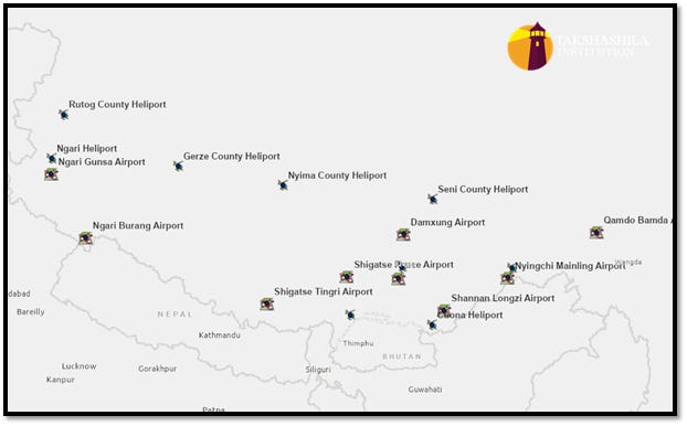
Figure 1 Shows the airbases and heliports in China’s Tibet Autonomous Region (TAR).
Notably, it is the pace of construction that should be of concern to India. China's utilisation of cutting-edge technology and infrastructure created for military personnel and civilians in these areas further underscores its long-term presence. Investments in agriculture, sustainable energy sources, and recreational amenities for the local population strongly suggest China's long-term intentions.
Moreover, the development of robust road and rail networks facilitates the efficient mobilisation of people and military resources, thereby promoting economic and military growth in the region. While China asserts that these infrastructure and development initiatives are geared toward sustainable regional progress, their proximity to the India-China Line of Actual Control (LAC) understandably raises concerns within the Indian establishment.
These activities may ostensibly appear geared towards improving the lives of residents in Tibet and Xinjiang, but they also serve clear military objectives. The sophisticated defence mechanisms and infrastructure at these airbases reflect China's preparedness for air combat operations, potentially reshaping the regional power dynamic.

Figure 2 Key airbases in Central TAR are studied in the present article.
This chapter focuses on the air infrastructure, specifically the key airbases that are operational or being built near Doklam and Arunachal regions. Among the five airbases covered here, Shigatse Peace Airport, Lhasa Gonggar Airport, and Nyingchi Mainling Airport are operational dual-use airports. At the same time, Damxung Airport and Shigatse Tingiri Airport are currently under construction airbases. Due to their dual nature, air infrastructure, and proximity to the Indian border, these airbases are strategically crucial for India. Hence, we cover them in the first installment of a continuing series.
Shigatse Peace Airport
Shigatse Airport is about 150 kilometres from the Line of Actual Control (LAC) and in a straight line to the Doklam region. The airport is situated at an altitude of 3,800 meters and is close to the Yarlung Shangpo River, a significant waterway that flows through the Tibetan area. The airport has two runways - one measuring 5 kilometres long and the other 3 kilometres long. The widths of the runways are 450 meters and 350 meters, respectively, and they are made of asphalt. The airport serves both civilian and military aviation operations.
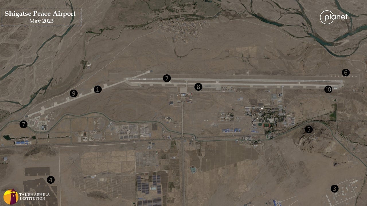
Figure 3 Represents the high-resolution satellite imagery of Shigatse Peace Airport, marked with critical air infrastructure.
Regarding civilian aircraft activity, Shigatse Airport can handle up to 13 weekly flights, primarily facilitating connections to domestic destinations and providing links to three airports in China. Moreover, the airport enjoys connectivity to the G318 highway.
Significant developments in civil and military infrastructure expansion near the airport are noticeable.
The primary energy sources for the base and its vicinity predominantly comprise water (hydroelectric power) and sunlight (solar energy). According to our calculations
1, the installed solar capacity was estimated to be around 350 megawatts in 2019. Remarkably, this capacity has increased nearly tenfold, currently standing at approximately 3,000 megawatts, or three gigawatts, as evidenced by the deployment of solar panels. It is anticipated that this capacity could reach up to 6,000 megawatts upon the completion of the expansion of solar farms.
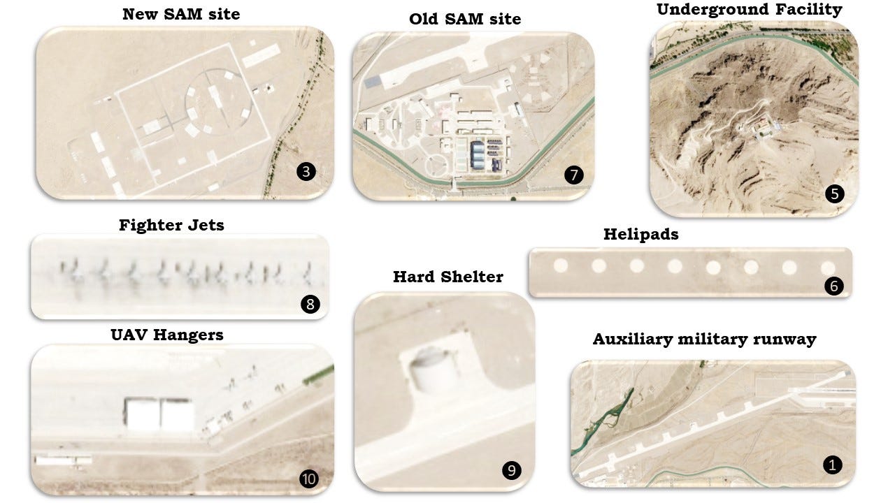
Figure 4 shows a closer view of the leading military facilities at Shigatse Peace Airport.
Our analysis of high-resolution satellite images captured in May 2023 by Planet Labs revealed that the military base can accommodate large aircraft, helicopters, and unmanned aerial vehicles (UAVs). On the day of imagery, the ground holds nearly a squadron of fighter jets, a larger advanced aircraft, four helicopters, and a fleet of 10 UAVs. We have also observed a significant presence of military vehicles, especially generator vehicles, adjacent to the UAVs.
Among the notable military installations within the base's confines are an under-construction underground facility, two newly constructed hangars designed for UAVs, a robust shelter to safeguard valuable assets, and three distinct surface-to-air missile sites.
For aircraft operations, the smaller runway features blast pens dedicated to UAVs and helicopters, while civilian activities are segregated from the western end of the larger runway. The central segment of the expansive runway is allocated for fighter jets and advanced larger aircraft, whereas the eastern portion's blast pens accommodate modern UAVs. Of particular interest is the placement of surface-to-air missile sites at both extremes of the airbase, underscoring the base's air defensive capabilities.
Lhasa Gonggar Airport
Nestled amidst breathtaking landscapes, Lhasa Gonggar Airport has established itself as the preeminent aviation hub in the Tibet region. With impressive capabilities, it facilitates 534 weekly flights and connects to 29 prominent airports across China. It is around 140 Km from the Bhutan border and 210 KM from India’s Tawang Airforce Station. It is one of the prominent dual-use airbases in the region.
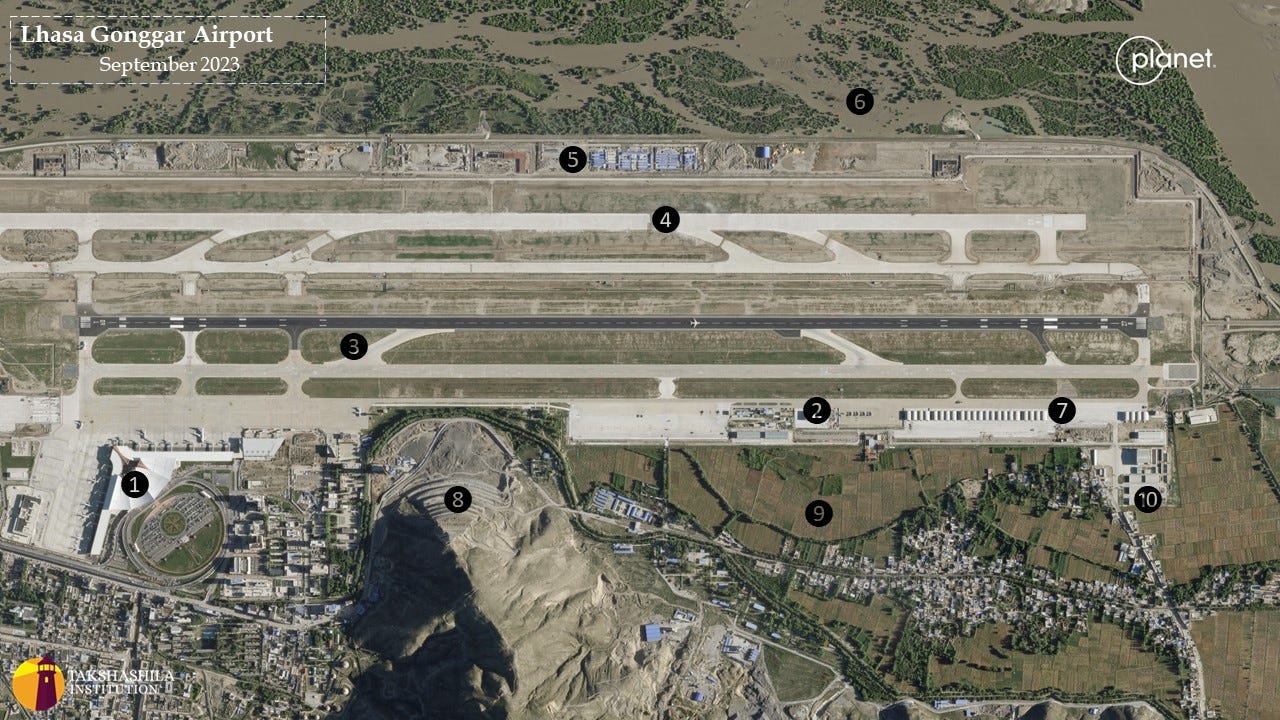
Figure 5 shows the high-resolution satellite imagery of Lhasa Gonggar airport, marked with critical air infrastructure.
Located at an altitude of 4,000 meters above sea level, Lhasa Gonggar Airport is a testament to modern engineering and logistical prowess. It boasts two meticulously designed runways with Rapid Exit Taxiways (RET), each measuring 4,000 meters long, accommodating various aircraft, from civilian planes to formidable fighter jets and cargo behemoths.
The airport is ingeniously divided into two distinct sections. The western precinct is dedicated to civilian air traffic and recently underwent a transformative upgrade with the inauguration of a state-of-the-art terminal in 2021. In stark contrast, the eastern section is a critical military installation, strategically separated by a formidable mountain ridge that aptly demarcates the two domains.
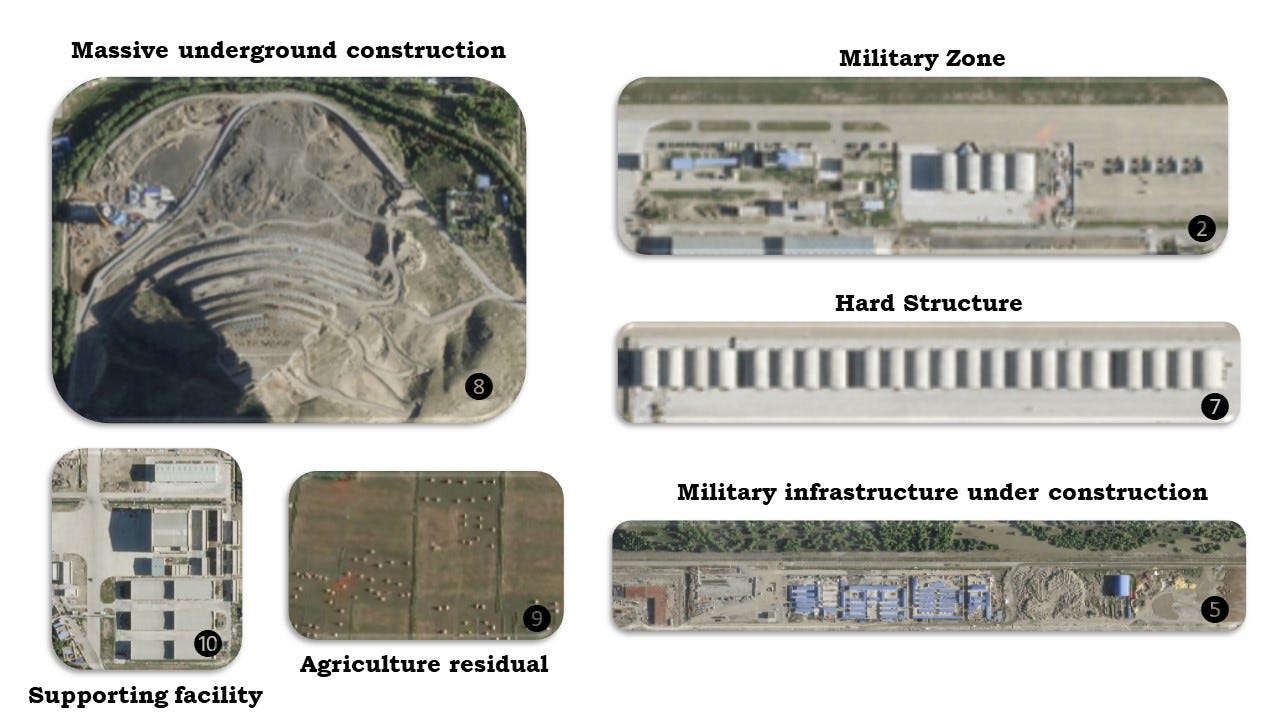
Figure 6 shows a closer view of the leading military facilities located at Lhasa Gonggar Airport.
Several military facilities stand out, particularly the robust complex shelters in the airport's eastern sector. These shelters are strictly for military use and have become dominant among regional airbases. In 2021, 24 of these hard structures were identified at the airbase. Today, this number has increased to an impressive 30, each able to house two fighter jets with dimensions of 17 meters in length and 13 meters in breadth. With a formidable lineup of 30 such hard structures bolstered by comprehensive support systems, the military aircraft presence at this facility is anticipated to surpass that of any other airport in the region.
A new runway and taxiway are being constructed in the northern part of a military base near the Yarlung-Sangpo River. The 4,000-meter-long runway appears exclusively for military use, and several hangars and other military buildings are erected in the same area.
Upon careful examination of the high-quality images, we observed two noteworthy features. Firstly, a large structure is built on the ridge's edge, separating the base's civilian and military sections. This structure could be linked to communication centres at the mountain ridge. Although it is unclear whether this facility has multiple uses, it will likely be exclusively for military purposes. Secondly, we noticed small white dots in the nearby fields, which we believe to be harvested crops bundled together.
Although the current image of September 2023 only showed the presence of four military jets, two helicopters, and several military vehicles, China is widely believed to operate sizable air assets.
Nyingchi Manling
Ningxi Manling is an airbase that serves both civilian and military purposes. It is located in the Tibetan region of China and is situated in close proximity to Indian territory. This airbase is the closest to the Indian border in this region, with a distance of only 13 kilometres from Arunachal Pradesh and 65 kilometres from India's Advanced Landing Ground in Tuting. Nestled at an elevation of 3,000 meters, this strategically important airbase is vital to nine airports across China and accommodating up to 85 flights every week. Boasting a single runway equipped with taxiways and measuring 3,000 meters in length, it offers the capability to handle large aircraft, facilitating the transportation of military supplies and the movement of a significant number of personnel.

Figure 7 shows the high-resolution satellite imagery of Nyingchi Manling airport, marked with critical air infrastructure.
The airbase's facilities are divided into two distinct sections, one catering to civilian operations, situated near the taxiway on the upper part of the base, and the other dedicated to military functions, positioned closer to the runway in the lower section.
Military infrastructure has undergone significant and rapid development since 2017, especially in this airbase. The infrastructure encompasses military barracks and garages within a controlled area. Notably, there have been 35 garages constructed in recent years. These garages may serve as essential storage facilities capable of accommodating supplies, making them instrumental in supporting ground forces and various operations.
The airbase is strategically linked to the S306 highway, providing crucial connectivity to other strategically significant regions. The proximity of the 35 garage blocks to a surface-to-air missile site is particularly important, enhancing the airbase's defences against threats from multiple directions. While this airbase primarily engages in military activities, it is also conceivable that it serves as a base for supporting units in the southeastern parts of the Tibetan region, where access to air infrastructure and airbases is relatively limited compared to other parts of Tibet due to complex mountainous terrain.
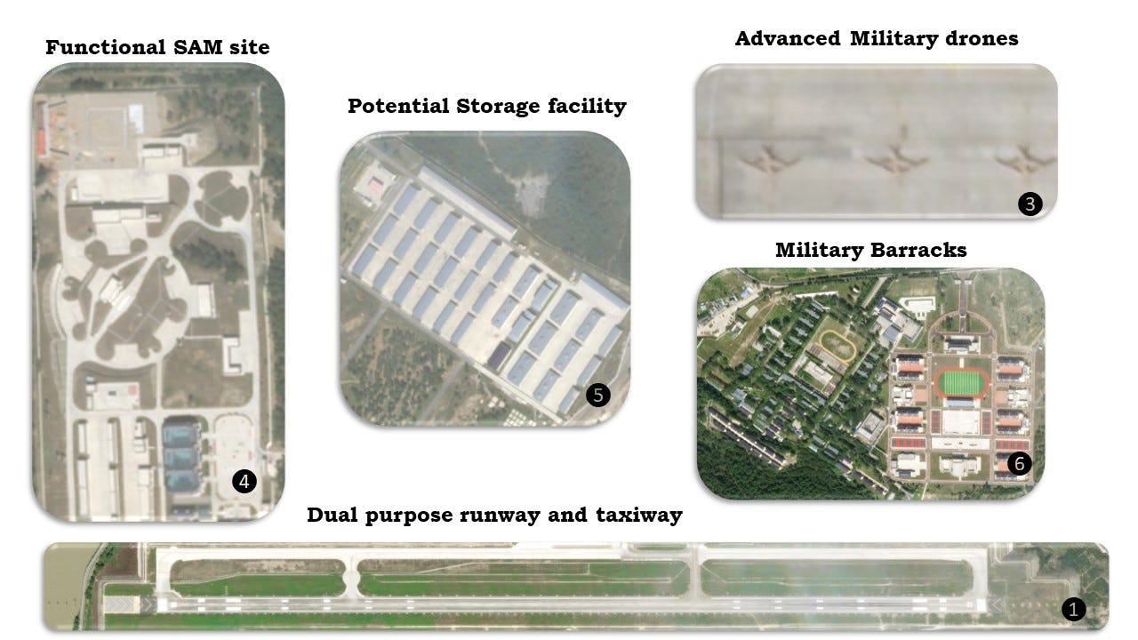
Figure 8 shows a closer view of the leading military facilities at Nyingchi Manling Airport.
Damxung Airbase
Damxung Airbase, perched at an impressive elevation of 4,300 meters, is situated approximately 270 kilometres away from the Indian border. Notably, it is also near Lhasa airport, just 90 kilometres from the capital of Tibet. Since 2020, there has been rapid and ongoing construction activity at this location, culminating in the completion of two expansive runways. Each of these runways spans an impressive five kilometres in length and extends to a width of 50 meters.
These runways are equipped with swift exit facilities, catering to various military requirements. Shortly, there are prospects for the development of hangars, garages, and barracks near the airbase. The airbase location, positioned 30 kilometres from Namcho Lake and above marshland, currently lacks substantial military structures. However, it holds significant potential for dual-purpose utilisation, serving both civilian travel and bolstering military capabilities in the region.

Figure 9 shows the high-resolution satellite imagery of the Damxung airbase (under construction) marked with critical air infrastructure.
Shigatse Tingri Airbase is one of several airbases that have been under construction since 2017. Due to its remote location, the airbase will likely serve military aircraft, as there is little need or demand for a civilian airport in such an isolated area.
Located approximately 65 kilometres from Nepal's border and perched at an impressive altitude of 4,300 meters, the airbase currently features a 4.5 kilometres long runway and taxiway. It is conveniently linked to Highway G219, which serves the surrounding region.
The airbase is located below the Bamchu River. The river's course was altered to establish the runway with no nearby towns or villages except for a small modern settlement, Ummiki village. Ummiki village has modern infrastructure, including agricultural lands and solar panels, that contributes to the region's development.
Additionally, supporting infrastructure for the airport is currently being developed, and it may take a few years for the airbase to become a fully established airport.
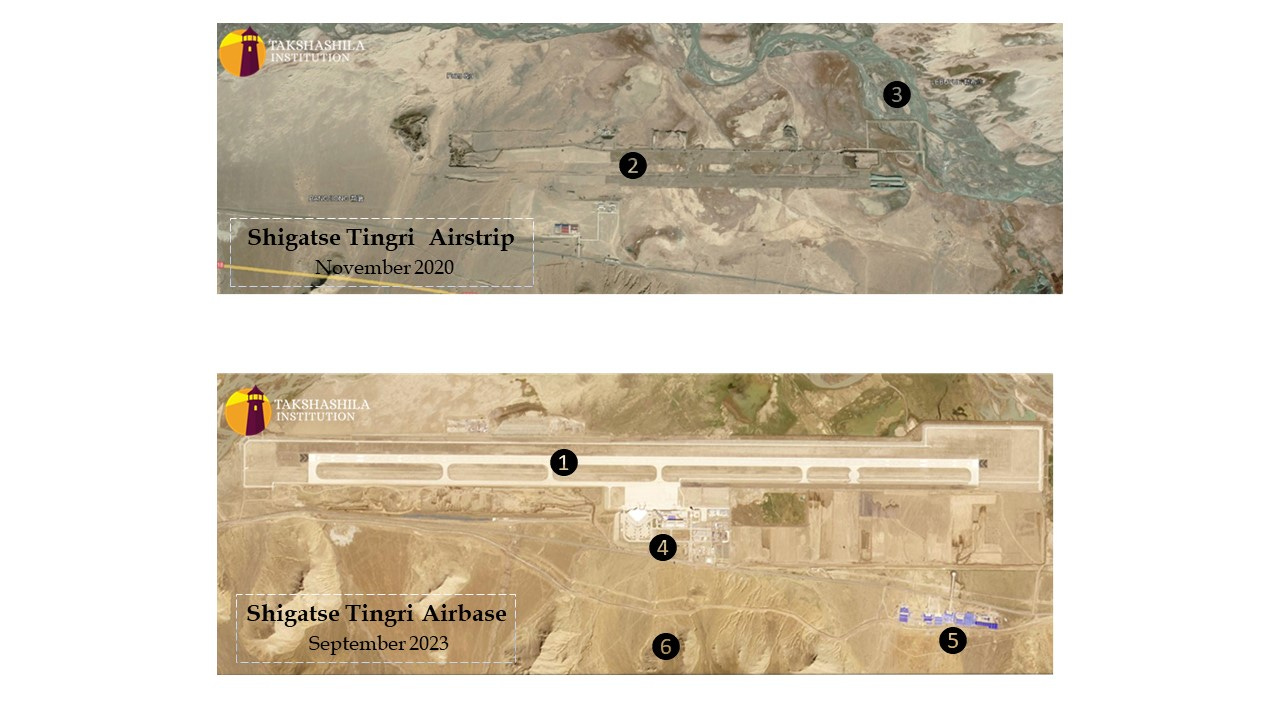
Figure 10 Shows satellite imagery of the Shigatse Tingri (under construction) airbase over two periods marked with critical air infrastructure.
Common insights
In our examination of the airbases, several commonalities have emerged:
Notably, these airbases have been strategically located adjacent to water resources, offering many advantages. These water sources serve various essential purposes, including meeting water consumption needs, facilitating construction activities, generating electricity, and supporting military applications. This choice may be attributed to the scarcity of flat, construction-friendly land with suitable soil conditions, often found near riverbanks. It can also be used as a weapon to disrupt the functioning of airbases.
The region has witnessed a rapid transformation in land use, with formerly barren lands now giving way to agriculture and urban development. This shift hints at a substantial increase in the local population in recent years.
These airbases are strategically nestled in valleys surrounded by high-altitude mountains, presenting advantages and disadvantages for air operations.
Finally, an interesting observation is that all military installations are being constructed with self-sufficient infrastructure and amenities to cater to the needs of military personnel and the associated civilian population.
Parting Shot
China's regional strategic infrastructure development is becoming increasingly evident, with a deliberate focus on areas of strategic significance. Among the five airbases examined, three are operational and have embraced a dual-purpose approach, catering not only to civilian needs, such as tourism and economic development but also serving as robust military assets supporting ground troops in the region (Appendix 1). China's strategy of establishing dual-purpose airports is gaining momentum. The expansion of housing infrastructure in military cantonments and broader villages indicates a significant increase in population compared to pre-standoff periods. However, the emphasis is not solely on quantity but on deploying cutting-edge military technologies and equipment, including advanced aircraft, helicopters, UAVs, missile systems, and anti-missile defence systems. These developments underscore China's heightened combat readiness in the region, signalling a significant shift in military capabilities.
Our detailed analysis of airbases in Tibet using open-source data and advanced remote sensing will be discussed in future newsletters. Stay tuned for captivating insights!
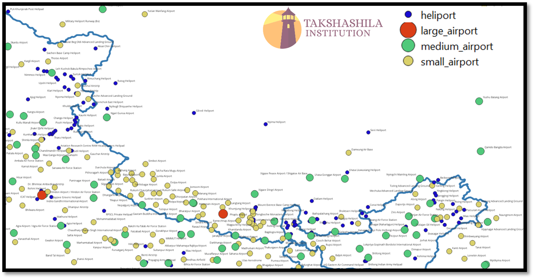
Figure 11 Indicates the different types of air infrastructure that exist in the region, which includes both civilian and military infrastructures of India and China.
No comments:
Post a Comment