


DR NITHIYANANDAM
In March 2021, the 14th five-year plan for China was passed by the National People's Congress in the Chinese Parliament. The plan established quantitative targets in various areas such as economy, trade, defence, science and technology, politics, social issues, culture, the environment, and other policy priorities. Unlike previous plans, this one includes a short section on "long-range objectives for 2035". The third section of the plan focuses on building a modern energy system, which involves constructing clean energy bases across China's administrative regions. One proposed project is to build a hub of renewable energy production in Nyingchi, consisting of hydropower, offshore wind power, and solar power plants. Out of five major “Modern energy System Construction projects”, the hydropower plant in the lower region of Yarlung Tsang Po (also known as the River Brahmaputra in India) is the most ambitious. It is anticipated to produce 60,000 MW, making it a giant hydropower plant. This is three times the current capacity of the world's largest power generation plant, Three Georges Dam, located on the Yangtze River, which has a capacity of 22,500 MW. According to Chinese media sources, the Dam will be built on Yarlung Tsang Po at the Great Bend, taking a "U" turn at Medog County before entering India's Arunachal Pradesh. Reports suggest that India is concerned about China constructing such a massive dam so close to its border (just 22 kilometres away), as it could reduce the natural flow of water downstream and potentially be used as a weapon against India by creating artificial floods. Experts are concerned that the construction of the giant Dam may cause significant harm to the environment and disrupt the livelihoods of individuals residing in the downstream area of the river in northeast India and Bangladesh.

Map showing the location of the potential dam site (Medog County) and river Yarlung Tsang Po (in China) allies Brahmaputra (in India). Source: ESRI data; map produced by the Geospatial Research Team (GRT).

The place at which the river Yarlung Tsang Po turns and flows in the direction of India is known as the Great “U” Bend. This satellite image was taken on November 11, 2021. Image Credit: Planet Labs PBC

The high-resolution satellite imagery of Medog County, taken on June 23, 2023, shows a well-developed town at an altitude of around 3500 feet near the proposed dam site. From the structure of buildings and associated features, it appears to have both civilian and military populations. Supporting Infrastructure, such as massive and well-connected roads, large shelters, solar farms (for electricity), concrete bridges (for crossing rivers), sports facilities (for recreation), and agricultural lands (for food), is found. Image Credit: Planet Labs PBC
The potential challenges involved in building Dam in Medog
Apart from its strategic significance, the Chinese government has recognised the immense potential for hydropower generation in the Yarlung Tsang Po region of Medog County, the last county before the Line of Actual Control (LAC). The proposed region is one of the world's deepest canyons, immediately after the "U" Bend, where the elevation drops by over 2000 metres. This location is between the Eastern Himalayas' two tallest mountains, Namache Barwa and Gyalaha Peri.
This is not the first time the idea of a hydropower plant in this area has been put forth. Before 2020, there were rumours about a hydropower plant at Namache Barwa that would necessitate the construction of tunnels to divert water from one side of the great bend to the other. It is worth noting that Namche Barwa holds sacred significance to the local communities in the region, including the Adi, Pemaköpa, and Tibetans. However, in the context of the 14th Five-Year Plan, it remains to be seen whether the previously rumoured engineering approach of tunnelling through the mountain will be pursued or if an entirely new engineering feat awaits the world.
China is embarking on a new engineering project that is different from its past dam-building efforts. The location in Medog presents significant challenges due to the rugged terrain and the need for a dam that spans 13 miles in width and three miles in depth within a deep canyon. Additionally, the water flows through the canyon varies naturally due to factors such as snowmelt and monsoon runoff, which must be considered. The project will showcase China's impressive engineering capabilities.
Our inference through satellite images indicates that China is preparing Yarlung Tsang Po to construct the historic Dam. The developments are happening systematically. Settlements and agricultural farms have swiftly been established along the riverbanks, potentially aiding in dam construction and potential growth. An analysis of land use and land cover (LU/LC) change using a 10-metre Sentinel satellite image has revealed a significant shift from open land to settlements or agricultural lands in just three years (2018–2021).

Rapid land use and land cover transformations have happened along Yarlung Tsang Po between the Great “U” bend and Medog County during 2018–21. The changes observed in some key villages and towns are shown on the map. It is observed that the built area and agricultural lands predominantly emerged during the mapping period. The framed (grey) maps are land use and land cover maps based on Sentinel-2 10 m datasets (Source: Esri) superimposed on moderate-resolution satellite imagery. Image Credit: Planet Labs PBC Refer to the same colour code while comparing the LU/LC map and satellite imagery.
The project's implementation may need help with the region's complicated topography and the effects of climate change. However, the 14th five-year plan emphasises the importance of “implementation”. On the 26th anniversary of the founding of the China Hydropower Engineering Society, Yan Zhiyong, the chairman of China Power Construction Corporation, sees this as a significant opportunity for the hydropower industry. Given the precedent of past dams failing to fulfil their intended purpose of achieving comprehensive flood control, manoeuvring through this intricate hydrological landscape without encountering potential disasters becomes quite challenging.
Status of existing operational dams in China
Before assessing the Medog dam project, we must examine other major hydroelectric initiatives in China.
The Three Gorges Dam
The Three Gorges Dam is built over the Yangtze River, the longest river in Asia and the third longest in the world. The Yangtze River basin covers one-fifth of China’s land territory and accommodates one-third of the people in China. The Dam was primarily built for flood control, irrigation, and electricity generation. However, it has failed to control floods as it was forced to release water due to the unprecedented water flow. It caused severe environmental impacts, such as flooding of animals and plants, threatening more than 400 plant species; the fish population is in peril; the scientific community believes the massive storage of water can create earthquakes; and, more than all, it has displaced more than a million people in the upstream and downstream areas due to changes made in the river morphology.
Our collaborative research using gravity sensors on satellites has shown that an unnatural water accumulation has altered the Earth's gravity. This change is visible in the gravity anomaly map, which shows higher gravity values compared to measurements based on elevation. The gravity gradient indicates relatively higher values in the stored water. The immense pressure from the water storage is suspected to have caused this anomaly. This is a cause for concern as it may lead to catastrophic natural disasters such as earthquakes and landslides. Despite 17 years since the Dam's completion, efforts to restore culture, environment, and ecology are ongoing.
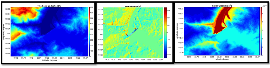
The First Image represents True Geoid undulation (the actual shape of the Earth's surface) simulated based on actual elevation data. The Second image represents the Anomaly in gravity observed at the dam; the places in red indicate a higher anomaly in the earth’s gravity values, which may be due to the stress created by storing water. The third image indicates the gravity gradient (spatial rate of change of gravity acceleration) that shows a higher value in the area where water is artificially stored compared to other places. Images Courtesy: Dr Rachit Bhatia, an expert on this matter.
The Mekong River Basin
The Mekong River spans through China, Myanmar, Laos, Thailand, Cambodia, and Vietnam and is home to diverse flora and fauna, including the endangered Mekong giant catfish and Irrawaddy dolphins. However, China has built 11 large dams in the upper river region, causing rising temperatures, changes in rainfall intensity, disruptions in river flow, floods, and droughts. This has destroyed homes, infrastructure, crops, and fisheries, resulting in food shortages and diminished livelihoods for vulnerable communities.
Countries in the lower basins accuse China of not regularly sharing water flow data. Currently, China only shares this information twice a year. This lack of information would make preparing for floods and droughts easier for these countries. Additionally, China is accused of using the water storage capacity in the upper basin as a weapon against the lower region by operating dams erratically. A report from Stimson reveals that China has released less water during the monsoon season while an unprecedented level of water is being released during the summer. This has caused significant disruptions to the way of life for people living in the region and the ecology of species in the plains.
Potential Impacts of Constructing Dam on Yarlung Tsang Po on India and Bangladesh
The Yarlung Tsang Po River originates from the Angsi glacier near Mount Kailash in Tibet and extends for about 3000 km before entering India as the Brahmaputra in Arunachal Pradesh. It collects water from tributaries and traverses through muddy jungle terrain during its journey. Upon reaching Assam, it combines with the Logit and Dibang rivers before entering Bangladesh as the Jamuna. Ultimately, it joins the Teesta and Ganges rivers and empties into the Bay of Bengal. Earlier, the upper regions of the river basin had a minimal human population, whereas the lower parts had millions of people. The basin encompasses an area of 570,000 square kilometres and is inhabited by 130 million people. The river plays a vital role in sustaining the livelihoods of many people in the northeastern states of India and a significant portion of Bangladesh.

The image displays the interconnected rivers of Yarlung Tsang Po and the Brahmaputra. From the Map, we can infer that if water is redirected from Yarlung Tsang Po to Tibet, the Brahmaputra River still receives a small quantity of water from other rivers within the basin. All the other rivers in the basin also originate from Tibet, which could potentially be subject to future control. Source: Data- ESRI, Map generated by GRT
We have identified three significant concerns for lower riparian countries, such as China, when an upper riparian country constructs several large dams within its territory.
- Climate Change and Disaster
- Water Shortage and diversion
- Impact on Natural Resources
Climate Change and Disaster
The scientific predictions for climate change in the region are concerning. As the Earth warms by 1.5 and 2.0 degrees Celsius, we can expect a higher rate of glacier melting and extreme precipitation. This could lead to unprecedented rates of water flow and floods. The north-eastern states of India and Bangladesh are already experiencing severe flood events and may face more challenges due to climate change. While climate change is perceived as a global issue, the area's topography determines specific disasters such as landslides, earthquakes, and floods. The Indian state of Arunachal Pradesh is highly susceptible to landslides, especially in the river basin. Additionally, the state is prone to frequent earthquakes due to orogenic tectonic activity, where the Eurasian and Indian subcontinent plates grind against each other. Constructing a massive dam in the fragile geology of the lower river reaches, which can stress the ecosystem, could lead to catastrophic events.

The Map indicates the Susceptible Areas to landslides (source: data from ESRI, map generated by GRT).
Impact on Natural Resources
The construction of large dams can significantly impact river systems, including water extraction for agriculture and power generation, as well as the displacement of human and non-human habitats. The proposed Medog hydroelectric project is located in a sparsely populated area with only 14,000 people, according to a 2017 news report. However, the physical development in the region would likely increase this number. Millions of people living in the Indian part of the region are at risk due to the impact on natural resources. The primary concern is the silt flowing from the upper riparian region, which is rich in minerals and vital for agriculture and riverbank stability. The construction of a massive dam in Medog could restrict the flow of silt, which would significantly impact the biodiversity of Arunachal Pradesh, one of India's two major biodiversity hotspots. In contrast, the Tibetan plateau receives less rainfall and tends to be colder, resulting in lower biodiversity, so China has little to lose from the dam's construction.
Water Shortage and Diversion
There is growing concern that areas downstream may face water shortages due to water diversion and limited storage capacity. Even a tiny alteration in water release schedules from these dams can significantly impact the surrounding communities and ecosystems that depend on consistent access to water and are accustomed to specific patterns. China's 14th five-year plan seeks to tap renewable energy potential in underutilised regions, which may require diverting the river that flows towards India at the "U" bend. Furthermore, China's actions concerning transboundary cooperation in the Mekong Basin have led people to anticipate a similar or worse situation in the Yarlung Tsang Po.

The Map displays the current power plants in China and the proposed Medog Dam. Based on this information, the western regions of China require a significant amount of energy. The proposed dam in Tibet intends to capitalise on the vast renewable energy resources available in the area—source: data from the World Bank; map generated by GRT.
Transboundary River Management Challenges
Despite numerous obstacles related to transboundary rivers, such as disputes over sovereignty and ownership, unequal distribution of water resources, environmental impacts, climate change concerns, limited information sharing and management, and geopolitical factors, the absence of a legal framework stands out as a significant barrier. Conflicts and difficulties in resolving disputes can arise without such a framework, hindering cooperation and efficient management.
India and China have not entered into a specific legal agreement regarding the Yarlung Tsangpo/Brahmaputra River, despite having previously held discussions on numerous topics, including the Brahmaputra. There are no current intentions for a comprehensive water-sharing agreement regarding this river.
Typically, transboundary disputes between lower and upper riparian countries are resolved through bilateral negotiations, international mediation, international arbitration, engagement with regional organisations, establishing treaties and agreements, and, in extreme cases, recourse to international courts. However, regarding the Yarlung Tsangpo/Brahmaputra River, the complex geopolitics between China and India, combined with ongoing border disputes and military tensions in the region, severely limit the options for resolving the dispute.
From China’s Perspective
China wants to achieve the ambitious target of achieving net carbon neutrality by 2060. To support this significant endeavour, the country is actively exploring utilising hydroelectric energy reserves in Tibet, focusing on the Yarlung Tsang Po River. With an immense capacity to generate up to 76 million KW of energy, the Yarlung Tsang Po River is considered a key source. Other viable rivers, such as the Nu, Lancing, and Jinsha, are also under scrutiny.
The Yarlung Tsang Po River can provide 30 million KW of energy. This exceptional potential is attributed to its strategic location amidst towering mountains, which enables an impressive flow rate and, thus, generation capacity that surpasses even the mighty Three Gorges Dam by threefold. China recognises the significance of dams and other renewable energy sources in ensuring energy self-sufficiency in the region and emphasises its commitment to taking stringent measures to safeguard the well-being of the local population, protect the environment, and preserve the area's cultural heritage.
Parting Shot
Based on our satellite imagery analysis, China is steadily progressing towards constructing massive dams in Medog, as seen through the rapid development of quality mountain roads, border villages, and smaller dams along the river. From a strategic perspective, monitoring these periodic developments closely is imperative. Despite China's utilisation of the latest technology and extreme precautions to safeguard the environment during the construction of the Medog dam, there is no guarantee that it will not lead to disastrous consequences, given the region's susceptibility and unpredictable nature.
Such developments will predominantly affect the Indian side, as the proposed dam site is only a few kilometres from India's Arunachal Pradesh. The rich ecosystem and cultural heritage of the people in north-eastern India and Bangladesh would inevitably suffer, as there are no stringent international regulations or effective treaties governing transboundary rivers. The dam's construction in Medog can be likened to playing with fire in the sensitive Himalayan ecosystem.
It is uncertain whether the Medog Dam could be used as a weapon against India, like in the recent conflict in Ukraine. However, any actions that disrupt the region's natural flow, patterns, and ecosystem could indirectly cause harm and potentially be exploited during dispute negotiations.
Unfortunately, India has limited resources to protect itself from this issue. However, building dams downstream can help prevent artificial flooding attempts. Monitoring the region during and after the dam is constructed is essential. India can also use remote sensing datasets, including high-resolution satellite images, radar data, and other IoT sensors, to monitor water levels, surface changes, and topography beyond its borders. This will help predict and give people early warnings. Additionally, it's essential to regularly apply diplomatic pressure on China and raise concerns on appropriate international platforms, backed up with evidence of potential impacts.
Overall, the ongoing and future developments in Medog demand vigilant attention and proactive measures to safeguard the transboundary region's interests and inhabitants. Furthermore, periodic Transboundary Environmental Impact Assessments can promote transparency and cooperation between upper and lower riparian nations.
No comments:
Post a Comment