


John Pollock
Myanmar’s Coco Islands in the Bay of Bengal have long been the subject of geopolitical intrigue and controversy among analysts, journalists, and policymakers across South Asia.
The most common allegation is that since the early 1990s, Myanmar has allowed a Chinese signals intelligence facility on the archipelago. Little evidence exists for such a facility, bar a heavily weathered radar station, but recent satellite photographs have raised concerns, especially for India, of increased activity on the islands.
The phantom Chinese intelligence post
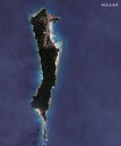
The islands are experiencing a steady makeover, with tell-tale signs of military modernization and facilities to support aircraft. Instead of the phantom Chinese intelligence post still prevalent in the popular imagination, the latest images reveal that Myanmar may soon be intending to conduct maritime surveillance operations from Great Coco Island, the largest in an isolated archipelago that lies just 55 kilometres north of India’s strategic Andaman and Nicobar Islands.
Beijing has staked a large investment in Myanmar to access Indian Ocean sea lanes
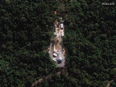
The photos from January 2023 by Maxar Technologies, which specializes in satellite imagery, show renewed levels of construction activity on Great Coco. Visible are two new hangars, a new causeway and what appears to be an accommodation bloc, all of which are visible in proximity to a freshly lengthened 2,300-metre runway and radar station. Visible as of late March on the southern tip of Great Coco, just beyond the causeway connecting the islands, is evidence of land clearing efforts indicating construction work to come.
The past two years of civil war in Myanmar have left it isolated internationally with the military junta, known as the Tatmadaw, increasingly fragile. Beijing has staked a large investment in the country via the China-Myanmar Economic Corridor to access Indian Ocean sea lanes as a way to bypass the Strait of Malacca – which has acted as a critical sea lane for shipping destined for China’s east coast – and direct energy imports instead over land into China’s Yunnan province.
 —
—The runway: Initially a length of 1,300m, the runway on Great Coco Island has been extended over the last decade to reach its current reported length of 2,300m. The runway has also been widened as of January 2023, and there are clear signs of ongoing construction visible, with new hangars at the centre of the image and new buildings located in the north. A large pier is also visible. Photo: Maxar Technologies
Growing evidence suggests Myanmar’s military coup has increased Beijing’s influence in the country. With Myanmar’s armed forces struggling to control large swaths of the country and with the economy in freefall, China seems to be shoring up the regime and protecting its investments for now. Chinese companies are believed to be operating on the ground, building major infrastructure projects such as deep-water ports, while the junta is allocating the few troops it has left to protect them.
The militarization of the Coco Islands could pose a significant security challenge to India
This has implications for India’s strategic interests in the region, as New Delhi seeks to counter China’s growing influence in South Asia and the Indian Ocean region. With the Coco Island developments, India may soon face a new airbase close by in a country increasingly tied to Beijing.
The militarization of the Coco Islands by the Tatmadaw, combined with the wider Chinese developments occurring inland, could pose a significant security challenge to India and its navy. The Andaman and Nicobar Islands provide India’s Eastern Fleet strategic depth in the Bay of Bengal and command approaches to the Strait of Malacca.
Chinese commercial shipping could soon bypass the strait and offload their cargo in Myanmar, nullifying India’s advantage. Meanwhile an expanded airbase on Great Coco opens the possibility that India may soon have to contend with Tatmadaw eyes watching the movements of its warships.
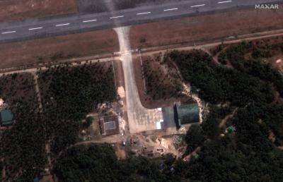 —
—This satellite image shows that building work for two aircraft hangars next to the runway is being carried out. The width of the hangar appears to be close to 40 metres, limiting the list of aircraft it may eventually accommodate but opening the possibility for high-performance aircraft be stationed there. Photo: Maxar Technologies
There is another concern. If China were to further apply pressure to the Tatmadaw, leveraging naval intelligence acquired from surveillance flights from Great Coco for desperately needed economic investment, it would give Beijing a key regional advantage over New Delhi.
In the 1990s, stories around Great Coco went from extravagant to outlandish
Fears that China could use Myanmar to monitor the Indian navy are not new, especially in the context of Great Coco. Conspiracy theories dominate the recent history of the Coco Island chain. Despite efforts to debunk them, they underpin almost all the conjecture around Great Coco, with any activity by Myanmar to reinforce its military presence seen as having a Chinese hand behind it. It is essential then to sort fact from fiction.
In the early 1990s, the first rumours emerged that the Chinese military had established a 45-50 metre antenna tower on Great Coco, equipped with signals intercept equipment. The timing broadly correlates with a warming of ties between Myanmar and Beijing following the 1988 crackdown on pro-democracy protests in Yangon.
 —
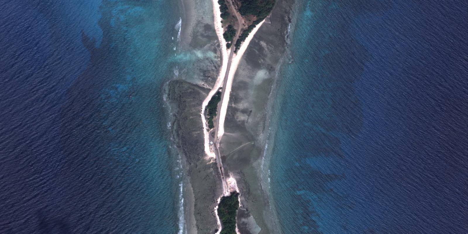
—The causeway at the southern end of Great Coco Island can be seen under construction, connecting the tip of the main island to a neighbouring island. As of March 2023, land-clearing efforts are now visible on the smaller island, with a path leading from the causeway to a deforested area indicating the future extension of Great Coco’s facilities. Photo: Maxar Technologies
As with today, this period saw Myanmar isolated internationally and becoming a major export market for military equipment for Beijing in exchange for raw materials.
As the decade progressed the stories around Great Coco went from extravagant to the outlandish. The antenna tower was turned into a full signals intelligence post, manned by the People’s Liberation Army, and then evolved into stories of Beijing fully leasing the islands from Myanmar.
It was widely accepted that there was a signals intelligence base on Great Coco. There was just one problem
Journalists in South Asia frequently ran stories of China tracking missile tests and launches by India’s space agency from Great Coco. High-ranking officials in New Delhi did little to dissuade the press of these notions. Indian officials cited alleged Chinese radar bases at Manaung Island, Hainggyi Island, Zar Dar Gyi Island, as well as Great Coco. The idea of a major Chinese presence in Myanmar’s islands percolated popular discourse in South Asia for more than a decade, with western analysts guilty of adding to the fever.
During the early 2000s, when talk of Beijing’s ‘string of pearls’ was at its height, Great Coco was always cited, and it was widely accepted that there was a signals intelligence base there. There was just one problem. No such base ever existed.
In 2005, Admiral Arun Prakash, India’s chief of naval staff, set the record straight, stating there was no Chinese military installation of any kind on Great Coco. That same year, Myanmar’s junta invited Indian defence officials to visit Great Coco, confirming the presence of an airstrip but no visible Chinese military presence. There were no radar dishes or antennae farms collecting information and probably never were.
Persistent rumours
To this day rumours of a Chinese intelligence post persist, but the available evidence points to the facilities being operated by the Tatmadaw. Instead of a non-existent Chinese intelligence post, the Bay of Bengal may soon have to contend with an airbase hosting Myanmar’s air force.
 —
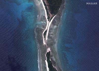
—The radar station: Located south of the runway on Great Coco Island, construction reportedly started in 2014 with completion two years later. The station has been the subject of much conjecture and is routinely cited as the main site of China’s activity on Great Coco, but the evidence is far from clear as no other facilities are visible on the island. Photographed in January 2023, the green dome covers the radar system to keep it protected from both the environment (note the weathered surface of the dome) and counter-surveillance efforts. Photo: Maxar Technologies
This brings us to the present day. The salience of Great Coco and its utility as a base for aircraft to survey the Indian Ocean is growing. The recent photographs released by Maxar add to the body of evidence indicating that the facilities on Great Coco are steadily being upgraded. The runway has been lengthened and new hangars are being built, combined with a limited land reclamation project.
Keep up to date with the latest articles and features, open access content from the archive, event invitations and more – straight into your inbox every fortnight.
With the Myanmar junta once again isolated by western sanctions and beset by instability from within, and with ties between Beijing and the West at their lowest since Tiananmen Square, the conditions mirror what was seen in 1988, but to a far greater extent. Myanmar’s junta has few friends left and the few assets it has are increasingly dependent on Chinese capital to sustain.
Great Coco is thus potentially a point of future leverage. Were Myanmar to get the base fully established, surveillance flights could track movements to and from the Andaman and Nicobar Islands. Given China’s well-established intelligence practices, local intelligence from Great Coco could find its way, either through espionage or consent, to Shanghai.
For India, Great Coco Island was in the past a place for outlandish theories. It may now become a real point of concern.
No comments:
Post a Comment