By Air Marshal Dhiraj Kukreja
04 Aug , 2016
 The North East is located at a crossroads between three major economies – East Asia, South Asia and Southeast Asia. This geopolitical advantage, has however, not really translated into the region’s economic development. Despite the high growth in India’s trade ties with Southeast Asia and China in the recent past, the region’s role has been marginal in terms of its contribution to trade and as a trade route. The NE region has not been able to integrate and benefit from the various regional and sub-regional initiatives that neighbouring countries have created.
After the 1962 Sino-Indian conflict, the development in the NE region was held back due to various reasons…
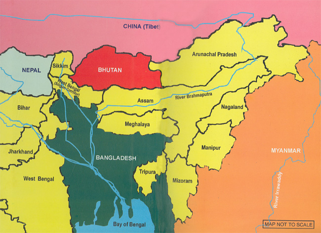
Any mention of North East (NE) India in strategic circles revives memories of the 1962 debacle. Despite the humiliating defeat then, the development of infrastructure in the area has been on the backburner for many years now. To the average Indian, the North East is generalised as Assam and many would not even know the names of all the States in the area! The region comprises eight states – Arunachal Pradesh, Manipur, Meghalaya, Mizoram, Nagaland, Sikkim, Tripura and Assam. Occupying eight per cent of India’s geographical spread, the states are home to only four per cent of the country’s population, while Assam accounts for 68 per cent of the population of the area.
The process of development has been rather slow in the North Eastern region for many reasons. The traditional system of self-governance and social customs of livelihood in the NE had remained virtually untouched during the British rule. Creation of a rail network for tea-growing areas for commercial interests was perhaps, the only major economic activity in the region. This was coupled with extraction of oil and some coal in the Assam, Meghalaya and Nagaland belt. Partition of the country in 1947, which carved out Bangladesh, hitherto East Pakistan, completely isolated the North Eastern region save for the slender Siliguri corridor, also known as the ‘Chicken’s Neck’, leading to severe distortion in the socio-economic situation. This corridor carries the road and rail infrastructure to the region and is just about 20 km wide at its narrowest, making communication long and difficult. Even the air routes pass through this narrow passage and demand for accurate navigation, especially in bad weather, which is quite a common occurrence. It was much later, after 1971 that civil aircraft were permitted to overfly Bangladesh.
Independence, in effect, cut off the markets and the centres of production by a political dividing line causing severe economic repercussions on the livelihood of people along the entire Eastern border of Bangladesh. All produce from agriculture, horticulture, and mines had until then, a ready market, not only in East Bengal, now Bangladesh, but through it to West Bengal and beyond too. For many years, the area has remained under-developed with gross under-utilisation of its economic potential, leading to social unrest and insurgency. Apart from the economic effects, the lack of physical infrastructure has had a strategic impact too, as was witnessed in 1962.
Roads are the nucleus of economic development, more so in the North East…
Infrastructure Development
Roads are the nucleus of economic development, more so in the North East. Road transportation is an important mode of travel in the hilly areas as other modes are either too expensive or difficult to construct. However, road infrastructure is relatively deficient in the area. The region, for geographic and sometimes strategic reasons, continued to have a very thin railway network too, and air services cannot be the sole channel to take care of the humungous transport needs of even one state, leave alone eight states! It is only now, after the announcement of India’s “Look East” policy, that due importance has been given to the development of the area. Thus, how the surface transportation network takes shape, is more than an integral part of the story of the development of the region, it is the key index.
The road network construction and upgrade had received a boost with the implementation of the Special Accelerated Road Development Programme (SADRP) in 2006. The first phase envisaged a 6,500 km network for completion by 2016, but only about 1,000 km of the proposed network has been completed; a 3,723 km network is planned for the second phase. An uncertain security situation with threats of violence by local insurgent groups demanding pay-offs has resulted in slow progress.
Another significant project under construction is the Kaladan Multi Mode Transportation Project (KMMTP) providing an alternate connectivity for the NE States. It includes improvement of Sittwe port in Arakan province in West Myanmar, construction of an inland waterway on the Kaladan River, and preparation of a highway transportation system linking the Mizoram capital of Aizwal. This project will reduce distance from Kolkata by approximately 1,300 km and will reduce the need to transport goods through the narrow Siliguri corridor. Work on the project commenced in April 2008, and is likely to be completed by 2016-2017.
Terrain makes air connectivity not just an option for travel but an absolute necessity…
Railways are considered the best mode of mass transportation in the country. However, in the hilly terrains of the NE region, it is difficult and expensive to build an exhaustive setup of rail networks. This accounts for the total absence or a nominal presence of railway lines in areas of hilly states like Arunachal Pradesh, Manipur, Meghalaya, and Mizoram. The railways’ presence in the North East region of the country is about 135 years old when the first passenger railway system came into being in 1881 between Dibrugarh and Sadiya. Since then, the railway system in the region has grown considerably. Even in Nagaland and Tripura, a railway route has been set up in the plain areas of the region. The Indian Railways is pursuing an ambitious plan to connect all State capitals with a rail network. Presently, the rail network in NE is 2,600 km long and 11 new projects will add another 880 km.
Two seemingly insignificant events about the NE region received miniscule mention in the national media in 2014. Over the years, however, these would make a significant impact on the development potential of the region. The first was the completion of railway line signifying the connectivity of Meghalaya with the Indian rail network. The second event was the commencement of rail services to Itanagar, on April 07, 2014, making it only the second state capital in the area to have rail connectivity. The daily services are proving a boon to the people of Arunachal Pradesh providing them a rail link to Guwahati. Further development of rail links will lead to bettering the economic status by improving transport efficiency and lowering the cost of transportation of commodities besides increasing tourism in the area.
Rail travel is becoming the lifeline of the NE region transporting essential goods all over. Today, apart from the increased passenger traffic, coal and petroleum products are moved from the region to the rest of India. Railways are also conscious of the strategic importance of this area, as the states of the region share international borders with Bangladesh, China, Myanmar, Bhutan and Nepal. It also provides a railhead for the landlocked Himalayan countries of Nepal and Bhutan and provides interchange facilities with Bangladesh.
The infrastructure in the region has been limited to the age-old rail and road connectivity through the Siliguri corridor activated since 1947…
After the 1962 Sino-Indian conflict, the development in the NE region was held back due to various reasons. The remoteness of the area, combined with lack of vision, with a misplaced logic that the area borders with other countries would be more secure if left undeveloped or under developed, are just to name a few. The recent attention that the area has been getting is after observing the development across the border in the Tibet Autonomous Region (TAR). China has developed the TAR into a logistics nightmare for India, to be able to launch a major offensive into the NE over 50,000 km of highways with about 1,000 km of laterals and a rail network to Lhasa are already in place, with more such infrastructure being built at a frenetic pace. Apart from the surface transport, China also has, at the last count, 15 new airfields with military capabilities. Coupled with a permanent optical fibre communication network, there is definitely a threat on our NE borders. The threat extends to the Northern borders too. It is not just the external threat that mandates the infrastructure development; the NE region has the longest standing insurgency movements in India. It is reported that out of the 65 terror organisations active in the country, more than 50 are in the NE region, of which about 35 are in Manipur!
Transportation is an organised service industry created to satisfy the basic needs of society. The social, political as well as economic development of a country depends largely on quick and smooth transportation. Some essentials of an effective transport network are speed, safety, regularity, flexibility, cost, and adaptability. As the air transport satisfies most of these except the cost factor, it is gaining importance day by day. Among all modes of transportation, air transport is the fastest. Air transport has brought about a connectivity revolution throughout the world. In a modern economy, air connectivity is vital especially in difficult terrain where the laying of roads and railways has been an almost prohibitive proposition.
That connectivity and infrastructure in NE region is of prime importance does not warrant repetition. Air connectivity in the NE region is not a new requirement. It was in 1928 that an aircraft landed at the Gymkhana Club in Jorhat, heralding the arrival of aviation in the NE region. The importance of air connectivity was realised in World War (WW) II and Jorhat became the first airfield to be developed. The region then got an extensive network of airports and airfields, of which, unfortunately, many are in a state of disuse, while a few are being upgraded for reuse. The following issues need emphasis.
Unpredictable connectivity hampers the smooth movement of both from the ‘mainland’ to the NE region…
Terrain makes air connectivity not just an option for travel but an absolute necessity.
Road and railways are highly capital intensive. Development of air infrastructure is much less so and hence highly appropriate even for shortfalls.
Thrust areas of development and those in which the NE region which have competitive advantage are agriculture, tourism, and services. Hence, for movement of perishable agro commodities, quick and reliable movement of cargo is necessary to find markets within and outside the region.
To meet the need to develop tourist circuits to harness the tourism potential of the region some policy decisions are required, such as, the restrictive inner permit rule to be eased for a majority of the areas, if not totally removed.
Developing some cities, such as Shillong, as educational hubs for which air transportation would be a boon.
The NE region lies in a seismic active zone and, hence, is earthquake prone. The area is also subject to heavy rains which cause extensive floods and landslides. Air transportation is the preferred mode of rescue in such eventualities.
The NE region States border three nations. While Myanmar and Bangladesh have normalised relations with India, with China, strategic reasons compel air transportation for rapid movement of the military.
Engineering is only one of the challenges that the task forces face…
Questions pertaining to the construction of so many airfields may arise in the minds of the reader as to how could such a number be constructed during WW II? The Americans had brought in a large workforce numbering 4,600, around November 1943, for the construction and maintenance of the railway network, of which a large number was diverted towards the construction of the airfields. The airfields were constructed as semi-pucca or grass strips reinforced with Perforated Steel Plates (PSP), which were sufficient to take the load of the aircraft of that generation. The area chosen was in the few open spaces available within the hills and valleys. It may be of interest to know that some of the ALGs were still using PSP grass strips for the AN-32 until the late 1990s; this writer too has extensive experience of landing on such strips.
The ‘Look East’ and the subsequent ‘Act East’ policies, propagated by the Government of India (GoI) for opening up the region internationally, especially to the neighbouring countries and ASEAN, has so far emphasized the use of surface transport. Nevertheless, connectivity by air is also being considered as an option.
As many as 11 airfields in Arunachal Pradesh alone, existing or new constructions, would be made available to improve connectivity in the region. Of these, some have already been inaugurated, while a few more would be ready by the end of the year. In Assam, facilities such as, extended runways, new hangars, additional fire-fighting facilities, navigational aids and night landing facilities, are either ready, or planned for completion in 2016-2017.
Ownership issues between the Indian Air Force (IAF), the Airports Authority of India (AAI) and the respective State Governments, are in the process of being resolved under the Ministry of Development of the NE Region of the GoI. However, it is unfortunate that delays caused by unnecessary litigation, at times on frivolous issues which do not keep the development and strategic nature of the region in mind, are not being resolved expeditiously.
Challenges to Development of Infrastructure
Broadly speaking, the infrastructure in the region has been limited to the age-old rail and road connectivity through the Siliguri corridor activated since 1947. The air connectivity is also limited, with most of the airports lacking night landing facilities and secure overnight parking services. Expenditure on the development of infrastructure cannot be a one-time affair; it is an ongoing process and one has to be patient for the process to bear fruit. There are many challenges to the development of infrastructure, some of which are listed.
The IAF is also in the process of making operational seven Advanced Landing Grounds (ALGs) in Arunachal Pradesh, which have been in a state of disuse for various reasons…
As a beginning, the lack of basics is a hurdle to the start and progress. Today, even a basic requirement such as bitumen, is transported by surface transport, from Haldia in West Bengal, to the region; a requirement that was not there in WW II! Adequate construction machinery, engineers and skilled work force are also in short supply. Unpredictable connectivity hampers the smooth movement of both from the ‘mainland’ to the NE region. Sand and riverbed material, a natural resource available in abundance in the area, is, however, available at a premium. Local reasons such as delayed licenses, bureaucratic delays for environmental permits and local mafia dictating the rates, inhibit availability.
The mighty Brahmaputra cuts through the plains of the region, dividing it into two parts. This, along with the numerous tributaries, makes the terrain prone to frequent flooding, not just in the monsoons, but even in the event of unseasonal rains and poses a major engineering challenge for deep foundations and high embankments, with the soil for raising the embankments at times needed to be carried over long distances. In an operational scenario, this will lead to a logistics nightmare with increased time for the movement of men and material and non-availability of the appropriate transport facilities.
Closer to the international border on the Northern side, the terrain poses a different challenge altogether. A hindering cause for stagnation of surface transport networks is the heavy rainfall for more than six months of the year leading to gully erosion. Loose soil base derived from alluvium soil leads to massive landslides, creep in the hilly region and numerous turbulent rivers and hill streams which change their course frequently leading to huge expenditure in repairing bridges, culverts, retention walls and spurs. The hilly tracts of the Himalayas are young fold mountains and face the brunt of the monsoon on the Indian side causing the area to become landslide-prone and experiencing flash floods. This, combined with the high altitude and thick tropical forests, poses a formidable challenge for even the basic task of carving out a mountainside road. The delays caused by these challenges are often compared with the relative ease with which the Chinese have developed the infrastructure in the TAR, without really understanding the difference. The Plateau is sheltered from the monsoons, making the going much easier as against the Indian side, where a project takes more time, more protection and a much more courageous workforce.
There are seven operational port locations in the state for import and export to the Kolkata and Haldia ports…
Deployment of the men and material in the difficult terrain requires an adequate airlift capability with an equal capability on ground. The IAF has been using its workhorse, the AN 32, combined with the ‘giant’ Mi-26 helicopter, on an as required basis, for both civil and military tasks. The arrival of the Chinook helicopter, as and when it comes, will make a tremendous difference to the IAF’s airlift capability.
The challenges on the Eastern and Southern border of the region are strikingly different. Along the Eastern side, the ranges are relatively of a lesser altitude but thickly forested and heavily affected by rain and hence, prone to mudslides. Planning permanent roads and railway tracks is an engineering challenge, especially if the two have to run along the same side of the hill. Moving towards the South, towards Tripura and Mizoram, the challenge is scarcity of rock, as compared to the North, where it is in abundance. Rock has to be brought over long distances either from the interior of the region, or even from Bangladesh!
Engineering is only one of the challenges that the task forces face. The workforce of any project has to be secured and compensated against insurgents and health hazards. The insurgents not only threaten the locals against working in these projects, but also resort to extortion from the contractors, who then accordingly raise the total cost. In addition to these issues that are unique to the area, are also issues that are prevalent across the country, namely, acquisition of land, environmental clearances and delays due to improperly prepared Project Reports. All these lead to time and cost overruns.
The challenges to ensure modern facilities for enhanced connectivity in the NE region are enormous…
Coordinating the Build-Up
Recent reports in the media indicate that the IAF has revived its efforts to enhance its operational reach and capability in the region. The process initiated in 2009, with the induction of SU-30 MKI aircraft at Tezpur and later in Chabua in 2011, already well-established airfields, but upgraded to accommodate new aircraft, has been gaining momentum. In November 2015, as a part of an Exercise, two SU-30 aircraft landed at Imphal in Nagaland indicating that the combat aircraft were now covering not just the Northern frontier but the region bordering Myanmar too.
As part of the capability building programme, the IAF is also in the process of making operational seven Advanced Landing Grounds (ALGs) in Arunachal Pradesh, which have been in a state of disuse for various reasons. Of the seven, the ALGs at Along and Ziro were inaugurated in March 2016 with three more at Mechuka, Pasighat and Tuting likely to be commissioned by mid-2016. All these airfields had part pavement and grass, reinforced by Perforated Steel Plates, and makeshift Control Towers, which have now been upgraded with paved runway surfaces and other facilities such as aprons for ground manoeuvering, an Air Traffic Control tower with associated infrastructure including night-landing facilities, a perimeter road and security wall. The new runway surface and other infrastructure, are being built to the exacting standards for any other modern airfield in the country, to accommodate fixed-wing operations by C-130 aircraft of the IAF and ATR-class of aircraft of the airlines.
Apart from the aviation related infrastructure that is in the process of being upgraded, the road and rail network are also being developed, though at a much slower pace. There needs to be synergy between the various agencies of the military and the civil for highways, railways and other infrastructure development projects such as power, irrigation and infrastructure for maximum effect and sharing of experience, for it is similar engineering skills, equipment, and material that is going to be used, making one dependent on the other. The Indian Railways (IR) and the National Highway Authority of India (NHAI) are now fully involved in the development process with master plans of a network of roads and rail lines, not only within the region but connecting neighbouring countries too.
The NE region has not been able to integrate and benefit from the various regional and sub-regional initiatives that neighbouring countries have created…
In order to get connectivity to the strategic and remote places of the region, roads should be an add-on to the railway network. At the origin and railheads, road connectivity is essential to provide feeder routes to the railway network in difficult terrain. The development of the road, rail and air network in the area, besides augmenting the operational capability, would also have economic benefits for the region.
One mode of transportation not much discussed is the use of waterways. NE India has many large and small rivers providing facilities for water transport, especially in the plains. From ancient times, until roads were constructed, Rivers Brahmaputra and Barak were the medium of transportation. However, with the partition of India in 1947, water transport received a serious blow as a foreign country was born between NE India and the port of Kolkata. It is estimated that the region has about 1,800 km of river routes that can be used by steamers and large country boats.
Inland water transport can be a viable, cost-effective alternative in the plains of the NE given the high cost of expanding other modes of transportation. It will also create employment opportunities, promote tourism, and open international routes for trade and commerce. However, this area too needs some dedicated attention towards improvement of facilities for night navigation and mechanical handling of cargo, increase in terminals and cargo vessels and the development of fairways and infrastructure. Unknown to many, an inland water transit and trade protocol exists between India and Bangladesh under which inland vessels of one country can transit through the specified routes of the other country. A 50:50 cargo-sharing by Indian and Bangladeshi vessels is permitted both for transit and inter country trade.
There are seven operational port locations in the state for import and export to the Kolkata and Haldia ports. An inland container depot near Guwahati already exists. Waterway connectivity between Mizoram and Myanmar and through Bangladesh, needs to be given a boost, as this could lead to enhanced trade opportunities and would reduce the pressure on the ‘Chicken’s Neck’.
The combined GDP of India, China and the ASEAN nations has the potential to create a trade stimulus environment…
Conclusion
The challenges to ensure modern facilities for enhanced connectivity in the NE region are enormous. The gap between the region and the rest of the country in terms of various developmental outcomes, productivity and capacity of people and institutions, is large and growing. The gap has to be bridged appropriately with various tailor-made sector policy interventions. Even within the region, there are vast differences. Hence, development strategies, with realistic timelines, need to be evolved depending upon prevailing resources, conditions and priorities. The successful transformation of investments into results on the ground in multi-modal transport sector requires a variety of strategic initiatives.
The North East is located at a crossroads between three major economies – East Asia, South Asia and Southeast Asia. This geopolitical advantage has however, not really translated into the region’s economic development. Despite the high growth in India’s trade ties with Southeast Asia and China in the recent past, the region’s role has been marginal in terms of its contribution to trade and as a trade route. The NE region has not been able to integrate and benefit from the various regional and sub-regional initiatives that neighbouring countries have created.
Though India has enunciated its ‘Look East’ policy, followed by the ‘Act East’ policy, with a view to cultivate economic and strategic relations with Southeast Asian nations, it has not been able to exploit successfully the benefits, due to an unconcerned attitude of the Central and State governments and hence, non-adherence to planned timelines. The combined GDP of India, China and the ASEAN nations has the potential to create a trade stimulus environment, which can contribute immensely to the economic development of NE India. It can only be exploited by creating and maintaining a sustainable infrastructure model.
© Copyright 2016 Indian Defence Review
No comments:
Post a Comment